Uploading...
Overall progress...
0%
File progress...
0%
Edit event: Wörner
T5 - Wörner
 Organized by:
Route
Wörner
| Elevation gain |
| Elevation loss |
| Distance |
| Duration |
| Highest altitude |
| Rating |
Gallery
Participants
You need to be logged in to see the participants
Weather
°
°
°
°
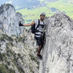
Description
Please read about the T-Scale before joining and only join if you enough experience for this hike, this is not for beginners and is quite long.
I expect you to have a steady pace, this means above 400 m gain/hour on the blue sections (T1 and T2).
Weather is partly cloudy, otherwise looks good for Sunday. This hike will be postponed to another day if the weather forecast gets worse..
Travel: RB6 to Garmisch from platform 31 leaving at 0632 and S6 to Mittenwald from platform 2 at 0802, reaching at 0823.
We can optionally a taxi to the nearest starting point, to be decided....If somebody already has a car please let me know I can add a carpool.
Return: Trains every 30 mins from Mittenwald, ideally should be back in Munich by 2030.
Duration: 10 to 11 hours (including breaks and we can stop at hochlandhuette on the way back).
Things to bring:
- proper hiking shoes;
- helmet;
- headlamp (just in case if it gets dark);
- cash for the hut or taxi;
- hiking poles;
- food and water for the day;
- layered clothing according to the latest weather forecast;
- GPX viewer with the route information;
- Deutschland ticket.
Optional:
- first aid kit.
Disclaimer: You are responsible for yourself. Hiking can be dangerous, I am not a mountain guide and this is not a guided tour. Make yourself familiar with the route and its requirements. It is recommended to have DAV Membership/Insurance.
Comments
Prem
1 year ago
Hey everyone, we will this route for tomorrow, avoids the boring T1 sections. Also please bring a towel and change of clothes. We can either try the waterfall on the way back or Isar. https://www.hiking-buddies.com/routes/routes_list/5764/
1
|
0
Prem
1 year ago
Please use the WhatsApp group for better communication https://chat.whatsapp.com/GozZBCszeaCD7sU3BwIwuO
0
|
0