Uploading...
Overall progress...
0%
File progress...
0%
Edit event: Zugspitze Gatterl up, Cable car down
T3 - Zugspitze Gatterl up, Cable car down
 Organized by:
Route
Zugspitze via Gatterl
| Elevation gain |
| Elevation loss |
| Distance |
| Duration |
| Highest altitude |
| Rating |
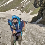
Gallery
Participants
You need to be logged in to see the participants
Weather
°
°
°
°
Description
Update:
Whatsapp Group to join
https://chat.whatsapp.com/I4dwbmva67XBJMZ39NNHdM
https://www.komoot.com/tour/41872629
https://www.youtube.com/watch?v=E4lXtm1J8Dg
Train station near start point: Ehrwald Zugspitzbahn (0.1 Km from start point)
Zugspitze (2962 m) is the highest peak in Germany. It lies south of the town of Garmisch-Partenkirchen, and the Austria–Germany border runs over its western summit. South of the mountain is the Zugspitzplatt, a high karst plateau with numerous caves. On the flanks of the Zugspitze are three glaciers, including the two largest in Germany [wikipedia].
This route is one of the easiest route to Zugspitze but you have to be very fit to be able to do it one day. Unlike many other routes it does not require climbing equiment.
Statistics: elevation gain 2460m, 500m descent, 21.1km distance, about 5hrs in total.
Ascent: The hike starts from the train station "Ehrwald Zugspitzbahn". You walk for about 50mins through the village to the "Ehrwald Almbahn Talstation", continue to "Ehrwald Alm". TBD, see the GPS track
Descent: Take the Austrian (not the German one to Garmisch!) cable car back to Ehrwald. Usually it operates till 16:40 (with some special events sometimes till 21:30). Walk down the "Ehrwald Zugspitzbahn" (about 35mins) or
Good to know
Leave Munich at 5.30 AM from HBF.

What to take:
Absolute must be are the good hiking shoes and backpack.
Must : enough water (it can be very sunny!) and food.
Note: I am not a professional mountain guide.
Each participant is responsible for him/herself and has to be prepared to participate in this grade of hike and to bring suitable equipment.
If the weather is not good we will postpone.
Comments
anup kumar
1 year ago
changing due to bad weather...
0
|
0
anup kumar
1 year ago
team, I have done many hikes and this is my first time doing Zugspitze, just want to know any anyone has done Zugspitze before?
0
|
0
anup kumar
1 year ago
Things to carry.
1. Good mood & energy.
2. Good hiking boots.
3. Optional - hiking stick, gloves.
4. Enough food/water.
5. Raincover, sunglasses, sunscreen, hat as per your wish.
I will create a WhatsApp group for better coordination, we will meet at Munich HBF @ 5.15AM, better to be early because if we miss the train we miss the hike.
0
|
0
anup kumar
1 year ago
Also, cable car down ticket need be purchased, we can buy at the top or online beforehand in the train also.
0
|
0
anup kumar
1 year ago
https://chat.whatsapp.com/I4dwbmva67XBJMZ39NNHdM
0
|
0
anup kumar
1 year ago
Please everyone join the WhatsApp group for coordination.
0
|
0