Uploading...
Overall progress...
0%
File progress...
0%
Edit event: Windautal Reinkarsee Kröndlhorn (T3, not T2)
T2 - Windautal Reinkarsee Kröndlhorn (T3, not T2)
27Oct
Sun
08:30
parkplatz Krumbach (Rettenbach, 6363, Austria) about 2 km after Gamskogelhütte, Westendorf, Tirol
 Organized by:
Marco Mecarozzi
Organized by:
Marco Mecarozzi
Route
Windautal Reinkarsee Kröndlhorn
| Elevation gain |
| Elevation loss |
| Distance |
| Duration |
| Highest altitude |
| Rating |
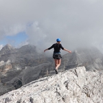
Gallery
Participants
You need to be logged in to see the participants
Weather
°
°
°
°
Description
This is a carpool hike. Please read carefully instructions for the hike and don´t just click on coming.
CARPOOL
Schedule: Hike starts at 8,30 am.
Drivers: add your car in carpool and put meeting point and time for it.
Passengers: Click on Carpool button. Read carefully all information about the car you join, check if there are any specific instructions. All the costs for the trip will be shared with people in the same car. Meeting point is decided by the driver, this information is in the "Carpool" button.
What do you need to take part to this hike.
1) enough fitness
2) please bring cash (many huts don´t accept card)
3) Team spirit. So put always an eye to the group and no gaps in the group please.
4) Motivation to join the event. At latest you can unjoin event 12 hours before. Thanks for understanding.
5) please be punctual. It is important to not start late!
This Sunday looks pretty good and moderately warm for the season. Let´s celebrate Autumn with a nice hike together! :)
Kröndlhorn
and Kröndlberg are a twin peak in the middle of Kitzbüheler Alpen.
2,444 m, the Kröndlhorn is the highest mountain in the Brixental region.
Kröndlhorn and Kröndlberg are the culmination points of the north –
south – running ridge, which divides Kelchsau Valley and Kurzer Grund to
the west from Windau valley to the east. The other summits in the
neighbouring area are minor ones, thus allowing the rocky outcrop of
Kröndhorn/Kröndlberg to dominate the surrounding.
Our starting point is at the end of WIndautal almost. The Windautal is a southern side valley of the Brixental and belongs to
the Westendorf area in Tyrol. Over a length of around 16 kilometers, one alpine
pasture follows the next. The tour to the Kröndlhörn starts at the very
end of the valley basin. The "Foisching" or "Krumbach" car parks can be used as starting points.
Access is possible by car. Entry into the Windautal is only possible
with a small local toll (approx. € 3.00). On the way to the starting
point, you are constantly accompanied by the wild and romantic Windauer
Ache - the small stream that runs through the side valley. Again and
again you will see smaller and larger waterfalls cascading down.
The
first section of the path takes
you mainly through woodland with many small waterways and streams
rushing around. In the woods you
will repeatedly come across openings from which you can catch beautiful
views of the entire Windautal. Here we might spot deer, stags, birds of
prey or other wild animals.
The Windautal is considered to be an extremely species-rich and densely
populated wilderness area. We keep hiking till at 2194m
sea level we reach the beautiful black Reinkarsee, which is around 1.5
hectares in extension. The landscape is particularly beautiful here.
The water is mostly very cold, since rarely exceeds 7°C. At
this point you are only around 500 m from the Salzburg border!
The
path
to the summit is not too far from Reinkarsee. From now on, you can
expect a more technical section (T3), some of which is secured with a
rope as a railing. Once you reach the top, contrary to
what you might expect, the summit is not adorned with a summit cross,
but rather a small memorial chapel. A true story about the chapel. Many
years ago, the farmer from
Kummer lived with his wife in Westendorf. The two tried several times to
start a family and have children. But fate brought them several
stillbirths one after the other. When it finally worked, the farmer's
wife gave birth to a living child. The child was so seriously ill that
the doctors did not think he had much of a chance of survival. In
desperation, the farmer from Kummer prayed to God and made a pact with
him: if the child survived and recovered, he would build a memorial
chapel in the highest place in the town out of gratitude. And so it
happened. We will take our time to enjoy the open views to Willder
Kaiser, Berchtesgadenerland and up to seventy 3000s peaks!
We
then come down for a short section along the same path till Reinkarsee,
then we take the path till Rotwandalm.
It is almost perfectly located at the end of the Windautal valley basin
at an altitude of 1,597 m. The view from the managed alpine pasture
stretches from the two sides of the valley to the Inn Valley. A place to
rest and relax in summertime especially! We keep going till we reach
our cars and we stop for drinks and food at Gamskogelhütte for a well
deserved stop!
I am not a professional guide, hiking can be risky. Everybody is responsible for him/herself and must familiarize with the route and its requirements.
In case of problems the hike day you can contact me at 017643285424.
Looking forward to see you!! 😊
Good to know
Waterproof hiking boots
Rain jacket
Cash to pay the hütte
Food/drinks for the way (no huts open till end hike)
flashlight
Comments
Lisette
1 year ago
Hoping someone will add another car :)
0
|
0