Uploading...
Overall progress...
0%
File progress...
0%
Edit event: [Switzerland] 99. Night after-work Uetliberg (from Albisrieden)
T2 - [Switzerland] 99. Night after-work Uetliberg (from Albisrieden)
 Organized by:
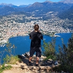
Route
[Switzerland] Uetliberg (from Albisrieden)
| Elevation gain |
| Elevation loss |
| Distance |
| Duration |
| Highest altitude |
| Rating |
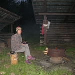
Gallery
Participants
You need to be logged in to see the participants
Weather
°
°
°
°
Description

Meeting point: Tram station in Albisrieden
Maps link: https://goo.gl/maps/op8t4JzvJj55huLQ9
Easily accessible by public transportation.
Easily accessible by bike.
Starting time: 18h30. Be early because buses can have some delays, we don't wait for latecomers.
Pace: beginner-friendly
Route: T2. The route is quite easy, there are almost no steep parts. The route is a little longer in comparison to other routes to Ueltiberg. One hour approximately is needed for ascent. Also, the landscape is a little different from what we are used in other hikes here (we start in the village part of the city and pass a horse farm for example)
After the hike: If there is interest we traditionally continue socializing after the hike in the nearby classic Swiss tavern (Sternen, Albisrieden).
Weather: Good weather is expected but with lower temperatures. It is a night hike so bring a lamp.
Comments
adrianne gilbride
1 year ago
running a few minutes late - meet u by the horses!
0
|
0
Severin Scherrer
1 year ago
Ok, starting to move now.
1
|
0