Uploading...
Overall progress...
0%
File progress...
0%
Edit event: [CH] Fuorcla Surlej from Pontresina to St. Moritz
T2 - [CH] Fuorcla Surlej from Pontresina to St. Moritz
 Organized by:
Route
Fuorcla Surlej from Pontresina to St. Moritz
| Elevation gain |
| Elevation loss |
| Distance |
| Duration |
| Highest altitude |
| Rating |
Gallery
Participants
You need to be logged in to see the participants
Weather
°
°
°
°
Description
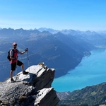
Engadin, the hiking mecca, the place to be in fall season. Join me in a spectacular hike from Pontresina throught the beautiful valley Val Roseg surrounded with many falling larches, rivers, white mountains. The hike will take us to Fuorcla Surlej, the best point to see Piz Surlej and iconic Piz Bernina, the highest peak of Graubünden. Due to its altitute, I expect a bit of snow between 2600 and 2700m, but it should be fine. In worst scenario we would turn back to Pontresina. If we continue according to the plan, we go in direction of the one and only St. Moritz, overlooking the surrounding lakes and orange trees. We should finish at Bahnhof St. Moritz before night.

Technical difficulty: The hike has difficulty T2. Please read the blog to understand the requirements for sac scale T2. I expect you are fit and have already done 1000m+ height difference, 25km long hikes before.
What to bring:
Waterproof hiking boots, gloves, hat
Food/drinks for the way
Warm clothes
Note: Please unjoin the event well in advance, if you don't plan to come. You cannot unjoin the event, when it is starting in less than 12 hours.
Disclaimer: Hiking can be dangerous. I am not a mountain guide. Everybody is responsible for her/himself. Make yourself familiar with the route and its requirements. It's recommended to download a map and bring a cell phone and first aid kit for emergencies.
Comments
Botond Kovács-Nüszl
1 year ago
Based on the past weekend experience above 2750m in Graubünden and the mild weather, I would not expect snow. Swisstopo is sadly unreliable in this matter.
2
|
0

Andrej Veškovo
1 year ago
top, thank you 😃
0
|
0