Uploading...
Overall progress...
0%
File progress...
0%
Edit event: [CH] (Not T5) Highest peak of the Alpstein – Säntis, loop
T5 - [CH] (Not T5) Highest peak of the Alpstein – Säntis, loop
 Organized by:
Route
Schwägalp to Säntis loop
| Elevation gain |
| Elevation loss |
| Distance |
| Duration |
| Highest altitude |
| Rating |
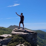
Gallery
Participants
You need to be logged in to see the participants
Weather
°
°
°
°
Description
Ladies and Gentleman,
I hereby present my plan for this weekend ! The weather forecast for this Saturday is great and we take the opportunity to hike up to the Säntis !
Hiking scale: Most of the route will be T3 and below, some parts will be T4.
Hiking highlights: Mountain inn Tierwis, Sky ladder (challenging segment, fairly safe), Berggasthaus Alter Säntis. The view of the Säntis and from the Säntis will be majestic.
Webcam from Säntis: Webcam Säntis Gipfel (HD Live) | Switzerland Tourism
If you want to come by public transport and the software doesn't allow you to join directly, you have to create or join a fake car in the carpool.
Starting and end point: Schwägalp, Säntis-Schwebebahn
https://maps.app.goo.gl/CUCLzPg5ZznM8CX18
How to arrive there (from Zurich HB):
07:09 Zurich HB (IR13) -> 08:21 Gossau SG(S23) ->08:47 Urnäsch, Bahnhof(B 791) -> 09:10 Schwägalp, Säntis-Schwebebahn
Elevation gain and loss: 1200m to 1300m
Highest point: 2502m
Pace: Moderate (one should be in a good physical shape)
Everyone should have: Hiking shoes, proper clothes, food, water, sunscreen.
I might cancel or reschedule the event in case the weather deteriorates by Saturday
Important: Download the .gpx file and load it into a proper app (Swisstopo, Atlas...). If the file fails to load into the app, try renaming it and setting the extension to .gpx.
Link to the whatsapp chat:
https://chat.whatsapp.com/FaT2d1RLpLD2yfdPSD2zhp
Everyone joins at their own risk.
Best regards
Comments
Atanas Bayraktarov
1 year ago
Link to the Whatsapp group:
https://chat.whatsapp.com/FaT2d1RLpLD2yfdPSD2zhp
0
|
0
Atanas Bayraktarov
1 year ago
You can find a clickable link in the description of the event
0
|
0