Uploading...
Overall progress...
0%
File progress...
0%
Edit event: Überschreitung der Leutascher und Patenkirchener Dreitorspitzen (2.682/2.634) T6-UIAA III-
T5 - Überschreitung der Leutascher und Patenkirchener Dreitorspitzen (2.682/2.634) T6-UIAA III-
 Organized by:
Route
Überschreitung der Leutascher und Patenkirchener Dreitorspitzen (2.682/2.634) T6-UIAA III-
| Elevation gain |
| Elevation loss |
| Distance |
| Duration |
| Highest altitude |
| Rating |
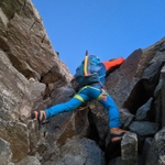
Gallery
Participants
You need to be logged in to see the participants
Weather
°
°
°
°
Description
Hey everyone,
I'm really excited to try out this fascinating traverse and would love for you to join! This route is only suitable for experienced hikers with solid footing, as some parts are quite exposed and leave little room for mistakes. Having some alpine experience is a must. Please take a look at the full description, get familiar with the route, and make sure it's a good fit for you.
If the weather doesn’t cooperate, we’ll switch to a different, safer route in the same area. Looking forward to an amazing adventure together!
pace in non Technical part will be more than 500 hm/m.
Helmet and headlamp is must and ropes might be helpful.
please read the follwoing if you are willing to pool your car:
This is a carpool hike. Please read carefully instructions for the hike and don´t just click on coming.
CARPOOL
Schedule: Hike starts at 7:30 am.
Drivers: add your car in carpool and put meeting point and time for it.
Passengers: Click on Carpool button. Read carefully all information about the car you join, check if there are any specific instructions. All the costs for the trip will be shared with people in the same car. Meeting point is decided by the driver, this information is in the "Carpool" button. Please make sure you are in a car once you join, and not just joining or you will you end up occupying spots in the hike without being able to reach the starting point on time.
Good to know
Ambitious mountain tour with a long ridge section and exposed climbing sections (max. II-III) from Leutasch through the Puittal over the Söllerpass to the Leutascher Dreitorspitze, further along the ridge over the three peaks of the Patenkirchener Dreitorspitzen, finally over the Signalkopf down to the Meilerhütte and through the Bergleintal back to the starting point.
One of the great ridge tours in the Wettersteingebirge is the crossing of the Dreitorspitzen.
Starting at the rather rarely visited Leutascher Dreitorspitze (2,682 m), the route follows the ridge to the Patenkirchener Dreitorspitze west summit (2,634 m), middle summit (2,622 m) and northeast summit (2,626 m). Continue past the Bayerländerturm to the Signalkopf (2,486 m) and from there down to the Meilerhütte (2,372 m).
You will be constantly moving along the ridge and will have to climb up and down several turrets, flanks and channels. The difficulty level II-III UIAA is not exceeded, but the terrain is mostly exposed, often brittle and free climbing must be mastered safely.
A high level of sure-footedness, a love of unsecured climbing and a penchant for ridges are, in addition to good physical condition, basic requirements for this tour.
To reach the ridge, you have to conquer about 1,600 meters of altitude from Leutasch, following the beautiful Puitbach through the Puittal to the Puitegg, along the Söllerrinne to the Söllerpass (2,259 m) and mostly without a path over the Leutascher Platt. Finally, up over a scree and through a gully prone to rockfall to the ridge.
For the descent from the Meilerhütte, we chose the Bergleintal, which saves you the ascent to the Söllerpass.
Directions
From the Puitbach-Ahrn hiking car park (€5/day), which is subject to a fee, behind the Landhaus Ahrn (between the districts of Lehner and Raindlau), follow the road towards Puitbach for a short distance (alternatively, take a small path along the Leutascher Ache, signposted “Chinesische Mauer”, which also joins the road a little later).
After 300 meters, turn left and follow the signs for Söllerpass on a dirt road across meadows into the forest. Keep left here and then right at the next fork. Shortly thereafter, the steep hiking trail 817/818 leads up along the Puitbach stream to Puitegg (1,500 m). The Puitalm awaits us here with its green meadows and idyllic flair, with the Scharnitzjoch at the end and the impressive south face of the Öfelekopf on the right.
A little later, we branch off to the right into the Söllerrinne, which in turn leads steeply up to the Söllerpass (2,259 m) – so we need to pay attention when finding the way.
Once at the top, the view of the vast Leutascher Platt opens up. Essentially, the tour is already easy to follow from here, starting with the Leutascher Dreitorspitze on the left and continuing to the Meilerhütte on the right. (Further to the right, the Wettersteingrat would join, but that's a project in itself...)
From the Söllerpass, turn left and head west, staying at the top for the time being, following tracks and occasional cairns. Then continue along a flank and go around a large basin on the right without losing any altitude to the path that leads from the Meilerhütte to the Leutascher Dreitorspitze. Cairns and the GPS track help with orientation.
Aiming for the prominent gully north of the Leutascher Dreitorspitze, a larger scree field must be crossed to find footholds. The steep gully is very prone to rockfall, as there is a lot of loose scree in the upper area. If other mountaineers are in the gully, a large distance should be kept – it is almost impossible to walk without triggering a rockfall.
Once you have reached the wind gap, you can already see the summit cross of the Leutascher Dreitorspitze on the left. Opposite, the Wettersteingebirge range spreads out with the Teufelsgrat, Schüsselkarspitze, Zugspitze, ...
After 80 meters of altitude, you reach the highest point of the tour, the Leutascher Dreitorspitze (2,682 m).
Back to the saddle and now always following the ridge, it goes mostly over turrets up and down, partly to the right through the flank (usually marked with cairns). Be careful at the first tower, which must be descended from the highest point on the right.
First over the western, then the middle Dreitorspitze (both only with cairns) you finally reach the northeastern Dreitorspitze (summit cross). In the direction of the north, the frequented Schachenhaus is recognizable, through the jagged ridge of the no longer distant Meilerhütte. But even in the last section, high concentration is required.
The northeast Dreitorspitze is climbed on the east side, over a rocky flank you reach the upper Dreitorscharte. This is traversed to the north and through a brittle channel it goes downhill over two clamping blocks. Here, if necessary, a rope can be helpful for lowering / abseiling.
After that, the Bayerländerturm is left on the right and an easy ascent of the Signalkopf is reached. From there, the route continues over scree and easy climbing terrain down to the Meilerhütte.
The route back to the valley and out to the parking lot is technically easy through the Bergleintal.
source: Überschreitung der Leutascher und Patenkirchener Dreitorspitzen ...
.**Legal Disclaimer**
Please read the following carefully before participating in the hike:
1. **Not a Guided Tour**: This hike is not a guided tour. I am only facilitating the organization of transportation to the starting point for like-minded, qualified, properly equipped, and reliable individuals.
2. **Self-Navigation**: Each participant is responsible for navigating themselves on the suggested route. You must have the necessary skills, experience, and equipment to independently complete the hike.
3. **Acknowledgement of Risk**: By joining this hike, you acknowledge that hiking can be dangerous. You understand and accept the inherent risks involved.
4. **Personal Responsibility**: You are fully responsible for your own safety and well-being during the hike. This includes being prepared for all weather conditions, having adequate supplies, and ensuring your physical readiness for the hike.
5. **Insurance**: You confirm that you have sufficient insurance coverage, such as membership with the German Alpine Club (DAV), Mountain Rescue Service (Bergrettung), or a similar organization. This insurance should cover any potential accidents or emergencies that may occur during the hike.
By participating in this hike, you agree to release the organizer from any liability for injuries, accidents, or other incidents that may occur. You participate at your own risk and responsibility.
If you decide to leave the group (go in front by yourself, or stopping for no reason), then we won’t search for you and you officially left the group, it is also the same if you don't bring required gears
Good to know
Comments

Amir ak
1 year ago
Sorry guys I made mistakes as I thought the I organized the event on Saturday, now I see it is on Sunday. On Sunday I am traveling to Cologne. Sorry for that. I talked to Amit and Amit is going to take care of that. So this event is going to be happening as it is and Amit wil take care of that. Have fun.
0
|
0

Joanna Michalczuk
1 year ago
No problem :) could you unjoin to let someone else take your spot?
0
|
0
Joanna Michalczuk
1 year ago
Meant unjoin car not hike, not sure what happens if you unjoin hike organized by you ;)
0
|
0
Amir ak
1 year ago
Amit knows the situation, he will decide with how many he wants to the hike, be patient
1
|
0
Amit Verma
1 year ago
Let's hope yesterday's snow melts by Sunday 😁
Current conditions: https://www.foto-webcam.eu/webcam/meilerhuette/
2
|
0

Amit Verma
1 year ago
Okay, so we can give it a try. There is still some snow. Bring ice axe, crampons, gaiters and headlamp. Plus warm clothes (quite windy) and enough food and drinks.
2
|
0