Uploading...
Overall progress...
0%
File progress...
0%
Edit event: Rohrkopf - Tegelberg (T4 not T5!)
T5 - Rohrkopf - Tegelberg (T4 not T5!)
 Organized by:
Route
Rohrkopf - Tegelberg
| Elevation gain |
| Elevation loss |
| Distance |
| Duration |
| Highest altitude |
| Rating |
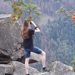
Gallery
Participants
You need to be logged in to see the participants
Weather
°
°
°
°
Description
Not for beginners, T4 (may be some small scrambling at the top). 400m per hour elevation gain (I want to avoid descending in the dark! Sunset is 16:40).
Please join the WhatsApp Group link:
https://chat.whatsapp.com/Ilxt2tDos9o77cwGGabixR
Sunday will be sunny and between 0-5 degrees at the kopf according to Meteoblue, so bring layers.
I checked and the Marienbrücke is currently open according to the website. There is a possibility I may choose to reverse the route depending on whether it is busier in the morning or afternoon to cross the bridge (my thinking is to avoid queues and tourists). Info here incase you want to check, there's an embedded link to current information part way down the page: https://www.hohenschwangau.de/en/nature-surroundings/marys-bridge
Plan
07.20 Meet at HBF gleis 30
07.39 RB74 departs (change at Buchloe to RB77)
09.39 arrive Füssen
10:05 bus 78 departs
10:13 arrive start point, start hiking to Rohrkopf (800m -1350m)
12:00 lunch at Rohrkopfhütte, it is open according to the site and looks great :-) https://www.hotelruebezahl.de/de/kulinarik/rohrkopfhuette-tegelberg/
13:00- 14:00 after lunch at Rohrkopfhütte (1320m) ascend Tegelberg (1700m)
14:00- 16:30 descent
Return transport
Neuschwanstein Castles, Schwangau bus stop
Bus departs at 16:40
Train departs Füssen (direct train) 17:05
Arrive MUC 19:19
or
17:40 bus
Train departs Füssen 18:17 (arrive Buchloe 19:31, dep Buchloe 19:36)
Arrive MUC 20:19
Good to know
I’ll create a WhatsApp on Saturday
What to bring:
Your best self obviously!
- Hiking shoes
-poles
- ID Card just incase
- cash for the hut
- Enough water for the hike + snacks
- Power bank
-Sunscreen (weather is due to be sunny)
-layers as it should be chilly
- spikes & gaiters just incase (some snow at the top)
-DAV insurance
Hiking can be dangerous. I am not a mountain guide, and everybody joining this hike does this at their own risk.
Comments

Hugo H
1 year ago
Hi, do you know if by chance the Hütte will be open?
0
|
0

Deborah
1 year ago
Hi Hugo, I planned for Rohrkopfhütte which looks well-rated (link and info already in the description ;-) ) because Tegelberghaus seems to be closed according to google.
0
|
0
Hugo H
1 year ago
Ok, ok, sounds nice, thanks for the info.
1
|
0
Deborah
1 year ago
Gerne!
0
|
0
Deborah
1 year ago
Hi All, the webcam from today showed a dusting of snow at the top of Tegelberg, can’t tell how much but maybe best to take spikes just incase
2
|
0
Corné de Groot
1 year ago
My Sbahn isn't going anymore... hope I will still make it on time 🤞
0
|
0