Uploading...
Overall progress...
0%
File progress...
0%
Edit event: Winter hike Spieser + Hirchberg(optional)
T3 - Winter hike Spieser + Hirchberg(optional)
 Organized by:
Route
Winter hike Spieser
| Elevation gain |
| Elevation loss |
| Distance |
| Duration |
| Highest altitude |
| Rating |
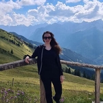
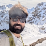
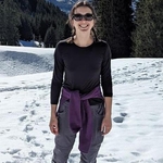
Gallery
Participants
You need to be logged in to see the participants
Weather
°
°
°
°
Description
Lets enjoy a day in Allgäue alps
Pace 350-400 hm/h
fit beginners are also Welcome to join
Flexibility is must, sense of humor always good
Also
Poles, gaiters, spikes -/head lamp is always good to have
Route Summary:
Starting Point: Begin at the parking lot, follow the main road west, crossing it before the large church. On the other side, follow a footpath marked "Hirschalpe" uphill. Continue straight along a paved road, passing a hospital, and enter the forest.
Main Route: At a fork, go right toward Ornach (not left toward Hirschalpe). Follow the road uphill, gaining elevation quickly. The forest thins, offering beautiful views of the Allgäu Alps. Just before the road ends, turn right onto a mountain path. Continue through meadows, reaching a wooden cross for a break. Shortly after, pass a sign for "Ornachgipfel," which refers to a mountain saddle east of Jochschrofen. Keep walking straight until reaching a terrain edge, where the path becomes steeper and rockier. At the next fork, turn left and climb across a meadow saddle toward Spieser (1651m).
Descent: From the summit cross, descend west (follow signs for "Hirschberg"). This section requires some sure-footedness over a short ridge and rocky gully. Continue down through meadows and follow signs for Hirschberg, first on a grassy path, then a wooden boardwalk over a wet meadow. Continue in the forest, passing some wooden huts and crossing a stream. Follow a road that leads to Klank Hütte, then take a meadow path south, through mixed forest, to Hirschberg, with great views of the route and Bad Hindelang below.
Final Section: Continue south, descending to a fork where you go left. Follow the path east to a stream and cross it on a bridge. Ascend slightly, ignore a branch to Hirschalpe, and follow a forest road left. Eventually, the path connects to a paved road. Descend to Oberjoch, passing a wildlife enclosure and the Alpenhotel's climbing park, and return to the parking lot.
Shortened Route: You can shorten the hike by descending directly from Spieser to Hirschalpe and then taking the road to Oberjoch.
Difficulty: Easy mountain hike with moderate elevation gain. Might be challenging in winter conditions. The route is mostly on pleasant uphill trails, with about a quarter of the hike on roads. It offers great views and is mostly sunny.
*Legal Disclaimer**
Please read the following carefully before participating in the hike:
1. **Not a Guided Tour**: This hike is not a guided tour. I am only facilitating the organization of transportation to the starting point for like-minded, qualified, properly equipped, and reliable individuals.
2. **Self-Navigation**: Each participant is responsible for navigating themselves on the suggested route. You must have the necessary skills, experience, and equipment to independently complete the hike.
3. **Acknowledgement of Risk**: By joining this hike, you acknowledge that hiking can be dangerous. You understand and accept the inherent risks involved.
4. **Personal Responsibility**: You are fully responsible for your own safety and well-being during the hike. This includes being prepared for all weather conditions, having adequate supplies, and ensuring your physical readiness for the hike.
5. **Insurance**: You confirm that you have sufficient insurance coverage, such as membership with the German Alpine Club (DAV), Mountain Rescue Service (Bergrettung), or a similar organization. This insurance should cover any potential accidents or emergencies that may occur during the hike.
By participating in this hike, you agree to release the organizer from any liability for injuries, accidents, or other incidents that may occur. You participate at your own risk and responsibility.
If you decide to leave the group (go in front by yourself, or stopping for no reason), then we won’t search for you and you officially left the group, it is also the same if you don't bring required gears
Comments
Zahra
1 year ago
The transport is with the 07:53 trains/buses to Oberjoch, right?
0
|
0
Amir ak
1 year ago
Yes,
1
|
0
Charlotte
1 year ago
What time will you arrive in Oberjoch? I live in Allgäu so will drive and meet you at the beginning of the hike
0
|
0
Amir ak
1 year ago
Verbindung am So. 19.01.2025
• von München Hbf, Abfahrt 07:53 Uhr Gl. 30 mit RE 78919
• nach Oberjoch B308, Bad Hindelang, Ankunft 10:37 Uhr mit Bus 48
Verbindung ansehen: https://www.bahn.de/buchung/start?vbid=328693fa-3c02-4f89-ad41-62067b5a0e3e
0
|
0
Charlotte
1 year ago
es tut mir leid aber ich muss absagen. ich hoffe jemand kann meinen Platz nehmen
0
|
0
Amir ak
1 year ago
We will take following connection as there is an issue with the original one we wanted to take
München Hbf Gl.27-36 → Oberjoch B308, Bad Hindelang
Sun 19.01.2025
BRB RB68 (62700)
To Füssen
From 08:07 München Hbf Gl.27-36, platform 31
To 08:48 Buchloe, platform 4
RE 17 (3382)
To Oberstdorf
From 09:07 Buchloe, platform 5
To 10:20 Sonthofen, platform 1
Bus 48
To Rathaus, Wertach
From 10:35 Bahnhof, Sonthofen
To 11:07 Oberjoch B308, Bad Hindelang
View journey: https://int.bahn.de/en/buchung/start?vbid=aa616614-142d-48d5-9f5c-088d976dbbac
1
|
0
Amir ak
1 year ago
Meeting at platform 31 or inside train around 8:00
0
|
0

Sandeep
1 year ago
Hello, I'm taking 7.20 train to Sonthofen. let me know if anyone reached there already.
0
|
0