Uploading...
Overall progress...
0%
File progress...
0%
Edit event: Winter hike to Rangiswanger Horn, lunch at Weltcup hut
T2 - Winter hike to Rangiswanger Horn, lunch at Weltcup hut
 Organized by:
Route
Winter hike to Rangiswanger Horn and Ofterschwanger Horn
| Elevation gain |
| Elevation loss |
| Distance |
| Duration |
| Highest altitude |
| Rating |
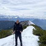
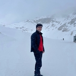
Gallery
Participants
You need to be logged in to see the participants
Weather
°
°
°
°
Description
Credits to Marco for creating the route. You can see his -as always- detailed description of the route and photos here. https://www.hiking-buddies.com/routes/events/10837/
Credits for the event photo go to Olya.
Our pace will be at least 400 elevation gain per hour so that we have no stress and enjoy the hut.
Hikers who do exercise regularly some sports and have done already hikes in the snow are welcome. Please only press the join button if you are genuinely committed to attending. Profiles which are rather empty, please PM me upon joining explaining their fitness and experience
Trains back: 16.40, 17.40 , 18.01
If you don't know what the T-Scale is, read this blog (click here). Note that the hike difficulty increases in winter.
Please ensure that you arrive on time, when in doubt plan a buffer.
Kindly remember to pack the following essentials:
- food and drinks for the entire day
- cash for the hut
- rain/sun protection according to the latest weather forecast
- Alpenverein / mountain insurance
- first aid kit for emergencies
- headlamp
- Spikes
Disclaimer: Please note that this list is not exhaustive and every participant should conduct their own research and self-assessment before joining. Additionally, please be advised that I am not a mountain guide and hiking can be risky. Therefore, you are responsible for your own safety and must familiarize yourself with the route and its requirements. I recommend downloading a map and bringing a cell phone for emergencies.
Good to know
Comments
Mohamed Aboushenif
1 year ago
If it is possible to increase number of participants that would be nice
0
|
0

Jeff Lynn
1 year ago
I live in Landberg. Assuming that you’re planning on taking the 7:20 from Munchen Hbf to Sonthofen, I‘ll join the train at Kaufering which is just one stop from my Wohnung.
0
|
0
Prakash Pandey
1 year ago
any WhatsApp group
0
|
0
Prakash Pandey
1 year ago
where are you guys ??
0
|
0
Jeff Lynn
1 year ago
Whereabouts are you on the train?
0
|
0
Jeff Lynn
1 year ago
I‘m at Kaufering.
0
|
0