Uploading...
Overall progress...
0%
File progress...
0%
Edit event: Beautiful view – Wildalpjoch loop from Talbahnhof Brannenburg
T3 - Beautiful view – Wildalpjoch loop from Talbahnhof Brannenburg
 Organized by:
Route
Beautiful view – Wildalpjoch loop from Talbahnhof Brannenburg
| Elevation gain |
| Elevation loss |
| Distance |
| Duration |
| Highest altitude |
| Rating |
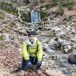
Gallery
Participants
You need to be logged in to see the participants
Weather
°
°
°
°
Description
ATTENTION. The original hike is 7 hours, since the day is still short, we will hike for 2 ½ -3hours, and then go down.
Get on train Rb54 leaves from Hauptbahnhof, Sunday, Jan 26th at AM 8:43, get off at Brannernberg.
Please use the
WhatsApp to communicate, I wont be able to help you if you text me directly.
Duration 7:24 (we will
spend 4 hours ONLY)
Total 17,6 km
elevation 1240 m
Ahmed
invited you to their group Tour:
https://www.komoot.com/tour/2027296417?share_token=aXE0a8QGuLYHlg8YZWAwYqnH8qrlZgeB47LI1Nm8VTjZykfjiR&ref=wtd
Good to know
No break-up during the hike, we do not race, we go out to enjoy nature and make friends and destress from work, our hike is not a competition.
Maps: we use Komoot for guidance, you can use any app you want however komoot is our default app.
How to get in touch with me or one of the Admin: a Whatsapp or
Telegram group will be created 1 day b4 the event and sent privately.
Disclaimer: I'm not a hiking guide , Hiking can be dangerous and
deadly, everyone hikes at their responsibility and risk. There are some
steep and exposed sections on this trail. Please read the detailed description
of the hike via the link posted above.
Comments
Ahmed Mansour
1 year ago
Whatsapp link had been sent privately
0
|
0