Uploading...
Overall progress...
0%
File progress...
0%
Edit event: [T3] Großer Rauher Kopf from Bischofswiesen (Berchtesgadener land)
T2 - [T3] Großer Rauher Kopf from Bischofswiesen (Berchtesgadener land)
 Organized by:
Route
Großer Rauher Kopf from Bischofswiesen (Berchtesgadener land)
| Elevation gain |
| Elevation loss |
| Distance |
| Duration |
| Highest altitude |
| Rating |
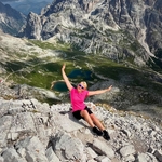
Gallery
Participants
You need to be logged in to see the participants
Weather
°
°
°
°
Description
Whatsapp group for the hike: https://chat.whatsapp.com/DloBVA7aKqzAxAc0szOnyk
As there are no more cars joining, I suggest for everyone to go by train
It's a beautiful south-west facing route on the south end of Untersberg, perfect for end of winter as the snow don't stay there for too long. Most of the way you'll have stunning views over Watzmann and Hohe Göll. There are some steep parts towards the peak, but nothing crazy. Depending on the snow conditions and the group, we might try to get to berchtesgadener Hochthrone, but I would not advertise is the path is on the eastern side and most likely is still covered by snow. The route shows the optimistic scenario, very probably we will need to turn back after Rauher Kopf, which will shorten the route to 700m high meters. Still a solid hike.
Note: it's not T2, rather a solid T3
The route starts from the train station, so it's possible to come by train, but I make carpool because of convenience. I start from Freilassing.
There is not hut on the top, but on the parking half-way down to the village, we might have a break there after the hike, but take your snacks for the way to be sure.
It's not a very beginer-friendly hike, decent fitness and some experience in mountains is required.
Equipment:
Regular hiking gear. Spikes and poles are recommended
- Warm clothes and hiking boots
- Good mood
- Cash for lunch at hut etc.
- food and drinks
- Spikes and a headlamp are always good to have
More about the route and photos: https://www.komoot.com/tour/2082058834?share_token=avXjQ5mn2evzqNbjmEeIH8GuglnVGudj5QFdtNKV04nG3ccxGd&ref=wtd
Good to know
Note: Please unjoin the event well in advance, if you don't plan to come. You cannot unjoin the event, when it is starting in less than 12 hours.
Disclaimer: Hiking can be dangerous. I am not a mountain guide. Everybody is responsible for her/himself. Make yourself familiar with the route and its requirements. It's recommended to download a map and bring a cell phone and first aid kit for emergencies.
Comments
Anna A.
1 year ago
I have created a whatsapp group for the hike, please join https://chat.whatsapp.com/DloBVA7aKqzAxAc0szOnyk
0
|
0