Uploading...
Overall progress...
0%
File progress...
0%
Edit event: [Switzerland] 116. Thursday's night after-work Uetliberg (from Albisgütli)
T2 - [Switzerland] 116. Thursday's night after-work Uetliberg (from Albisgütli)
 Organized by:
Route
Uetliberg (from Albisgütli)
| Elevation gain |
| Elevation loss |
| Distance |
| Duration |
| Highest altitude |
| Rating |
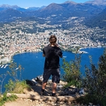
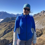
Gallery
Participants
You need to be logged in to see the participants
Weather
°
°
°
°
Description
General information
Meeting point: Near the bench at the start of the trail. Maps link: https://goo.gl/maps/LgCULujv3g9gct269

Easily accessible by public transport.
By bike, you need a little uphill endurance, which could be a good warmup activity.
There is also payable parking.
Starting time: 18h30. That is the starting time, we don't wait for latecomers
Pace: beginner-friendly
Route: T2. We will use the route through the woods, which uses stairs to ascent. If it is not moody, we will use the attractive exit to the viewing Plato, otherwise stairs to the top. We will need approximately 40 minutes to go up. We will use the panoramic path to descend.
Weather: Very good weather is expected. The event is held in any weather; bring a rain jacket or an umbrella in rainy weather. It is a night hike, so a lamp is recommended.
Gear
Recommended: hiking or approach boots, clothes to dress up on the top, a lamp
Comments
Severin Scherrer
11 months ago
I was hoping I could make it but it seems that I'm not quite fit yet. So I will skip today and hope to join next week. Enjoy the hike!
0
|
0
Paula M
11 months ago
i will be ca 10 min late, will try to catch you on a way
0
|
0