Uploading...
Overall progress...
0%
File progress...
0%
Edit event: [CH] Lugano - Monte Boglia (different route, check the exact map in the description)
T2 - [CH] Lugano - Monte Boglia (different route, check the exact map in the description)
 Organized by:
Route
[CH] Lugano - Monte Boglia
| Elevation gain |
| Elevation loss |
| Distance |
| Duration |
| Highest altitude |
| Rating |
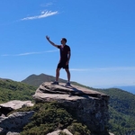
Gallery
Participants
You need to be logged in to see the participants
Weather
°
°
°
°
Description
Ladies and Gentleman,
A rainy day awaits us in Zürich, I hereby present my escape plan for this weekend !
Hiking highlights: Lugano, Monte Brè, Monte Boglia.
Important: There was an internal server error preventing me from adding the exact map. Here you can access it: https://www.komoot.com/tour/2119353582 (T2 hike)
Those who want to come by public transport should create a virtual car in the carpool.
Starting point: Viganello, S. Siro bus stop (https://maps.app.goo.gl/mWbXZeKcQdzYuwQa9)
End point: Aldesago Villaggio (https://maps.app.goo.gl/RmEM3u837MURR4yK7)
Optional: We can continue on foot to Lugano after the end point is reached
How to arrive there (from Zurich HB):
07:05 Zurich HB (IC2) -> 08:58 Lugano -> 5 minute walk ->09:10 (B461)Lugano, Stazione Nord -> 09:22 Viganello, S. Siro
Elevation gain and loss: around 1200
Highest point: 1516m
Pace: Moderate (one should be in a good physical shape)
Everyone should have: Hiking shoes, proper clothes, food, water, sunscreen.
I might cancel or reschedule the event in case the weather deteriorates by Saturday
Important: Download the .gpx file and load it into a proper app (Swisstopo, Atlas...). If the file fails to load into the app, try renaming it and setting the extension to .gpx.
Link to WhatsApp chat: https://chat.whatsapp.com/Bv3xxXykD7dJfCgby29xz4
Everyone joins at their own responsibility.
Best regards
Comments
Atanas Bayraktarov
11 months ago
Link to whatsapp chat: https://chat.whatsapp.com/Bv3xxXykD7dJfCgby29xz4
0
|
0