Uploading...
Overall progress...
0%
File progress...
0%
Edit event: Schlegeisspeicher to Croda rossa: an impressive red balcony towards the silence of glaciers
T4 - Schlegeisspeicher to Croda rossa: an impressive red balcony towards the silence of glaciers
12Jul
Sat
09:00
Parkplatz Schlegeisspeicher, Dornauberg 118, 6295 Dornauberg, Austria ( https://g.co/kgs/qdwPsMW )
 Organized by:
Marco Mecarozzi
Organized by:
Marco Mecarozzi
Route
Schlegeisspeicher to Croda rossa. An impressive red balcony towards the silence of glaciers
| Elevation gain |
| Elevation loss |
| Distance |
| Duration |
| Highest altitude |
| Rating |
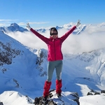
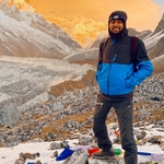
Gallery
Participants
You need to be logged in to see the participants
Weather
°
°
°
°
Description
This is a carpool hike. Please read carefully instructions for the hike and don´t just click on coming. If you join without being in a car, you will be removed from the hike.
CARPOOL
Schedule: Hike starts at 9,00 am.
Drivers: add your car in carpool and put meeting point and time for it.
Passengers: Click on Carpool button. Read carefully all information about the car you join, check if there are any specific instructions. All the costs for the trip will be shared with people in the same car. Meeting point is decided by the driver, this information is in the "Carpool" button.
What do you need to take part to this hike.
1) enough fitness
2) please bring cash (many huts don´t accept card)
3) Team spirit. So put always an eye to the group and no gaps in the group please.
4) Motivation to join the event. At latest you can unjoin event 12 hours before. Thanks for understanding.
5) please be punctual. Train couild be packed and would be nice to sit together!
This weekend in Tirol weather looks not exactly reliable and thunderstorms are still possible so better waiting for more reliable weather next weekend for this tour!
Let´s go and climb a beautiful mountain and have a coffee in Italy! :)
Croda rossa or Rotbachlspitze (2897m) is a geological gem with a colorful summit structure with magnificent views of the Hochfeiler and Ortler groups, the Stubai and Ötztal Alps, and of course, South Tyrol. The summit region is a colorful geological wonder!
From the parking lot at Schlegeisspeicher, we head west on the path to the Unterschrammach cirque. After just half an hour, we find ourselves in a beautiful little high valley along the Unterschrammach stream with fantastic views of the Schammacher, Fußstein, and Olperer. We climb another step to the Hinterboden at approximately 2,300 m, another flat basin with a few small lakes. The high trail from the Olperer Hut joins here, and the ascent to the Alpeiner Scharte branches off. We choose the third alternative and ascend westward to the Pfitscherjoch, which is marked on the signpost as a 3-hour hike with a black dot. While there were a few hikers on the way to Hinterboden, it now becomes lonely until shortly before the Pfitscherjoch. We first climb steeply up the Unterschrammach cirque to approximately 2,400 m in switchbacks before leaving the cirque on a beautiful high trail. Far below, the turquoise Schlegeis reservoir and the Zamser Grund lake shimmer, where the many parked cars glitter in the sun. The trail continues leisurely beneath the rocky shoulder known as the Ameiskopf into the wide Oberschrammach cirque, which we now cross at almost the same elevation. Along the way, we cross the Oberschrammachbach stream, which resembles a long, polished stone slide. Countless markers, barrier tape, and information signs guide us uphill a bit, allowing us to easily cross the stream in the scree-covered section. After leaving the Oberschrammach cirque, the landscape changes, and we enter the gentler, grassy area of the Pfitscherjoch pass. Opposite, we can already see the summit destination, the Rotbachlspitze, with its long western ridge, which we then ascend. We now lose about 150 meters of elevation to the Pfitscherjoch, which we reach after 2.5 hours. Several small lakes are on our way creating a lovely landscape really. We start our ascent to the Rothbachlspitz, turning east about 200 meters before the Pfitscher-Hoch-Haus (north of it) and climbing, exactly on the border between North and South Tyrol, through meadows and over the gentle western ridge to the Rotbachlspitze. The climb to the scree-covered summit slope is relatively easy and hardly exposed. Here, too, the path is easy and the slope is not dangerous. However, it gets steeper and steeper, and the trail builders have been extremely stingy with switchbacks. So we climb the increasingly steep slope directly to the top, in places. The sandy and scree-covered ground is easily accessible, and we make good progress. Finally, we reach the summit of the Rotbachlspitze (2897 m). The views are impressive. Above all, the Hochferner massif to our south, with its dark rocky ridges and the glacier flowing down into them, has an almost Western Alpine feel. To the north, the entire Tux main ridge reveals itself in all its beauty and south Tirol the other side.
The descent begins on the same path back to the Pfitscher Joch. We stop for a rewarding break at Pfitscher Joch Haus. There, we turn right and descend along the uneven forest road to the Zamserbach stream, which meanders heavily here on the flat terrain. From here, we continue to the Lavitzalm andfurther through the Zamser Grund directly to the Schlegeis reservoir, having always open views to it. A very nice end of the hike.
I
am not a professional guide, hiking can be risky. Everybody is
responsible for him/herself and must familiarize with the route and its
requirements.
In case of problems the hike day you can contact me at 017643285424.
Looking forward to see you!! 😊
Good to know
Hiking shoes
Rain jacket
Cash for the ride and to pay the hütte
Food/drinks for the way
Comments

Amin Etezazian
8 months ago
I just added my car with 4 free places. feel free to join the car.
2
|
0

Marco Mecarozzi
8 months ago
Great to see you there, my dear friend
1
|
0
Krystyna Kantor
8 months ago
See you on Saturday. I live super close to Ostbahnhof.
0
|
0
Marco Mecarozzi
8 months ago
https://www.bergfex.at/sommer/ginzling/wetter/berg/ Hallo everyone. Weather looks good at the Moment. Worst case Will be some Clouds or sun and clouds. By the way Will be much colder than last few weeks. In last days It has been snowing above 2000. So dress extra layers and bring a jacket with you because around the summit temperatures Will be below 10 for sure. The most of the Trail should be snowfree, but I expect some snow on the way to the peak on the section from Pfitscher Joch Hause maybe above 2400-2500 m. So bring spikes with you. I think summiting should work but worst case, those who dont feel to face Winter conditions in Summer, could be waiting at the hut because from there we go then down back to the cars. Anyway keep monitoring weather conditions till tomorrow. Have a nice day. :)
4
|
0

Deborah
8 months ago
Hey Marco! I take it we bring our own lunch right? (sounds like we would stop at the hütte on the way back from the peak, around 15km into the hike so that would be quite late I’m guessing)
1
|
0
Marco Mecarozzi
8 months ago
Hey Deb. I Always recomend anyway to have energetic food for the way. We definitely Need to eat something on the way. Probably we Will have several but short breaks on the way and a longer One at Pfitscher Joch Haus. I Guess we Will be down at the car around 17 and back to Munich around 19,30-20.
4
|
0
Marco Mecarozzi
8 months ago
Hallo everyone. One more update. I contacted the hut. The path is completely snow free. There is snow, but not so much only at Croda Rossa summit. Concerning weather forecasts, it should be dry according to them. Expect a mix of clouds and sun but mostly no rain. Dress in layers because the temperature will be changing according to the altitude, clouds or sun and side of the mountain we are during the day. Any further relevant update, I will write in case later on. :)
5
|
0
niladri deb
8 months ago
thanks Marco 😊
1
|
0
Marco Mecarozzi
8 months ago
Last forecasts Just checked online for Pfitscherjoch. https://kachelmannwetter.com/at/wetter/3319479-pfitscher-joch
2
|
0
Deborah
8 months ago
I guess it’s going to be too cold for swimming in the reservoir… right 😉🫣
0
|
0
Deborah
8 months ago
Hmm my optimism… a veritably tropical 7 degrees at the spitze and 13 at the speicher… 🙈 #alpinesummer
0
|
0
Marco Mecarozzi
8 months ago
I think It would be too cold for me ahahaha but wont forbid you. You can try the small lakes close to Pfitscher Joch Haus 😅
0
|
0
Marco Mecarozzi
8 months ago
https://chat.whatsapp.com/BZjdSf3ZZBcBF0oQPxan5b join here if you are interested in photos from the day :)
0
|
0