Uploading...
Overall progress...
0%
File progress...
0%
Edit event: [CH] (T4) Ridge hike in Glarus (Sööligrat)
T2 - [CH] (T4) Ridge hike in Glarus (Sööligrat)
 Organized by:
Route
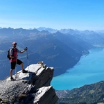
Ridge hike in Glarus (Sööligrat)
| Elevation gain |
| Elevation loss |
| Distance |
| Duration |
| Highest altitude |
| Rating |
Gallery
Participants
You need to be logged in to see the participants
Weather
°
°
°
°
Description
Hoi hikers,
Let's use the improved weather forecast and go for a ridge hike in Glarus.
This region seemed to be popular in the last weeks, so I decided to go there as well.
Some description and pictures: https://www.hikr.org/tour/post138352.html
Whatsapp chat: https://chat.whatsapp.com/Etd3TnrjOSt0V3hMbdhJVh?mode=r_c
Weather forecast: Tierberg Sunny until 14:00. Low chance (<25%) of rain until 17:00. Hopefully we finish the hike without any rain, but if not, a light rain would not hurt us, as the last part of the hike is T1 and we are not made of sugar.
Note: This is a medium/fast paced hike, not suitable for beginners and includes a T4 section.
How to get there:
Journey by public transport: ZH HB - Siebnen-Wangen - Innerthal, Gemeindeplatz
The train (S25 to Linthal) departs at 07:43 from ZH HB.
Journey by car: Use gps. Note: This is not a roundtrip.
Meeting point:
9:00 AM - Innerthal, Gemeindeplatz bus stop
Hike:
The hike will last ca. 7 hours with a lot of viewpoints.
Short (ca. 20 Min.) picnic lunch break at the Tierberg.
The pace will be medium/fast (>500 hm/h) with enough time to admire the landscape. In case you're not able to keep up with the pace, we might split up.
Equipment:
Proper hiking boots, poles, picnic lunch, snacks, enough water, proper clothes acc. to the weather, sunscreen, good mood and fitness.
Standard Disclaimer:
This is not a guided tour, every individual is responsible for their actions, choices and judgement. It is your own responsibility to assess your fitness condition for this hike, to assure adequate equipment (boots, clothes, etc.), insurance coverage and to check and evaluate the weather forecast. In case professional rescue services are required, you will be responsible for the costs.
The organiser holds no responsibility for any injuries or death that might result directly or indirectly from this event. The organiser does not warrant the accuracy of the description of the hike.
By joining the hike, you accept the terms explained above.
Please be aware that you join at your own risk.
Additional notes
The organizer is no professional guide. Participants are responsible for themselves, must do their own research about the route, and must be able to navigate by themselves (in case the groups split for some reason, for example).
Out of respect for the others, please be on time. If you happen to be late, contact the organizer.
If you have a No Show in your profile (= you did not show up to a hike you signed up to in the past), I may exclude you from the event.
Unjoining allowed until 12 hours before the start of the event. If you are unable to be join for whatever reason, contact the organizer.
Comments
Botond Kovács-Nüszl
8 months ago
Whatsapp chat link added.
0
|
0