Uploading...
Overall progress...
0%
File progress...
0%
Edit event: Westliche Karwendelspitze (2385 m) Nördliche Linderspitze (2372 m) Mittlere Linderspitze (2239 m)
T5 - Westliche Karwendelspitze (2385 m) Nördliche Linderspitze (2372 m) Mittlere Linderspitze (2239 m)
 Organized by:
Route
Westliche Karwendelspitze (2385 m) Nördliche Linderspitze (2372 m) Mittlere Linderspitze (2239 m)
| Elevation gain |
| Elevation loss |
| Distance |
| Duration |
| Highest altitude |
| Rating |
Gallery
Participants
You need to be logged in to see the participants
Weather
°
°
°
°
Description
Description
📅 Sunday 24.08.2025 | ☀️ Beautiful weather forecast | 👫 Open to all interested hikers
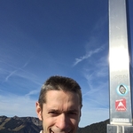
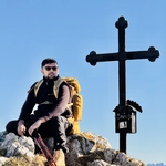
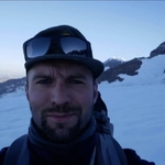
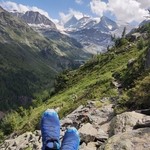
On 24.08.2025, the weather was perfect for hiking – sunny skies, mild temperatures, and clear visibility across the Karwendel mountains. Starting from Gamseck (1717 m), the trail ascended steadily towards the majestic Westliche Karwendelspitze (2385 m), offering breathtaking panoramic views. The route continued along the ridge, connecting the impressive Linderspitzen – Nördliche, Mittlere, and Südliche – each revealing dramatic rock formations and deep alpine valleys. Sulzleklammspitze (2321 m) and Kirchlespitze (2301 m) crowned the adventure with stunning views over the Isartal and alpine wilderness. This challenging yet rewarding hike combined steep ascents, rocky paths, and exposed ridgelines, ideal for experienced hikers. A truly unforgettable day in the heart of the Karwendel!
About Car. In my car just will go 5 person if more than 5 you can add your own car and join than other members you in your car .
📍 Plan for the Day
🚗 Meeting & Pickup Point:
Westpark, 81377 München U-Bhan Station
We’ll carpool from here, please be on time.
👉 Google Maps Link
05:50AM – Pickup at Westpark, 81377 München U-Bhan Station
06:50 AM –Breakfast Bäckerei Rieger in Mittenwald mit Selbstbedienungs-Cafe till 7:10Am
07:20 AM- Parking Wanderparkplatz am Waudl (kostenpflichtig), 82481 Mittenwald
07:30 AM-- 1- Start Hike to Gamseck (1717 m)
2-Westliche Karwendelspitze (2385 m)
3-Nördliche Linderspitze (2372 m)
4-Mittlere Linderspitze (2239 m)
5-Südliche Linderspitze (2304 m)
6-Sulzleklammspitze (2321 m)
7-Kirchlespitze (2301 m)
12:00 AM – Summit reached, enjoy panoramic views Breaks in hutt eat something than go forwerd
12:45 PM – Start Ahed other peaks and than go back our start point
16:30 PM – Reached to Parking Wanderparkplatz am Waudl (kostenpflichtig), 82481 Mittenwald
16:45PM-- Will be go back to München
18:15 PM – Approximate arrival at Westpark, 81377 München U-Bhan Station
Note : When you have good stamina and you are fit than you join please this day .Because of elevation is 1723m.
🎒 What to Bring
- Snacks (optional, breakfast and lunch as planned above)
- Plenty of water – it will be a warm, sunny day
- Cash – some mountain huts don’t accept cards
- Kletterset (essential)
- Hiking shoes (essential)
- Hiking shoes (essential)
- Hiking poles (optional)
- Good vibes and team spirit! 😊
This is a friendly group hike, and we aim to keep the group together and enjoy the experience as a team.
Good to know
⚠️ Disclaimer
This is not a guided tour. I’m simply organizing and sharing the plan. Everyone is responsible for their own safety and participation.
*Legal Disclaimer**
I am not a guide. Everybody is responsible for themselves. Make yourself familiar with the route and its requirements. The organizer holds no responsibility for any injuries or death that might result directly or indirectly from this event. The organizer does not warrant the accuracy of the description of the event. By joining the event, you accept the terms explained above. Please be aware that you join at your own risk.
Please read the following carefully before participating in the hike:
1. **Not a Guided Tour**: This hike is not a guided tour. I am only facilitating the organization of transportation to the starting point for like-minded, qualified, properly equipped, and reliable individuals.
2. **Self-Navigation**: Each participant is responsible for navigating themselves on the suggested route. You must have the necessary skills, experience, and equipment to independently complete the hike.
3. **Acknowledgement of Risk**: By joining this hike, you acknowledge that hiking can be dangerous. You understand and accept the inherent risks involved.
4. **Personal Responsibility**: You are fully responsible for your own safety and well-being during the hike. This includes being prepared for all weather conditions, having adequate supplies, and ensuring your physical readiness for the hike.
5. **Insurance**: You confirm that you have sufficient insurance coverage, such as membership with the German Alpine Club (DAV), Mountain Rescue Service (Bergrettung), or a similar organization. This insurance should cover any potential accidents or emergencies that may occur during the hike.
By participating in this hike, you agree to release the organizer from any liability for injuries, accidents, or other incidents that may occur. You participate at your own risk and responsibility.
If you decide to leave the group (go in front by yourself, or stopping for no reason), then we won’t search for you and you officially left the group, it is also the same if you don't bring required gears
Comments
Alex M.
7 months ago
It's difficult to park directly at Westpark. What would work is parking in the vicinity in 5-10 minutes walking time and gathering at the entrance to Norma, Ehrwalder Str. 2, 81377 München, https://maps.app.goo.gl/htBkYu58cR9mkeGA9 .
0
|
0
Shakeel Danish
7 months ago
yes you are right. let we will see about it. and chek it again. 😉
0
|
0
Alex M.
7 months ago
Unfortunately, I am out for tomorrow, too. My apologies that the announcement is less than 12 h before the start (so I can’t remove my car). But, as no one was registered for my car, it should not be an issue. I hope you enjoy the hike!
0
|
0
Alexander Kanz
7 months ago
I won't be able to join too, my knee has been hurting all evening long, I don't think I can cover the elevation tomorrow 🫤
0
|
0
Florin
6 months ago
I would like to ask you guys about your experience on this hike. Not sure if you are still seeing this message.
0
|
0
Shakeel Danish
6 months ago
Hi Florian .. It was great hike very smooth trail and easy route . But just deppend on weather condition .
0
|
0
Florin
6 months ago
Great to hear and thank you for answering. I had some doubts specifically about the direct path you took up the mountain, I didn't know what to expect. From your comment it sounds like there is nothing to be concerned about.
0
|
0