Uploading...
Overall progress...
0%
File progress...
0%
Edit event: Griesen – Hoher Brand – Schellkopf – Griesen
T4 - Griesen – Hoher Brand – Schellkopf – Griesen
05Oct
Sun
08:00
Between Griesen 22, 82467 Griesen, and the bridge over Neidernach, entrace into the forest, https://maps.app.goo.gl/UYhCgtFdMSpFZMyF6
 Organized by:
Alex M.
Organized by:
Alex M.
Route
Griesen – Hoher Brand – Schellkopf – Griesen
| Elevation gain |
| Elevation loss |
| Distance |
| Duration |
| Highest altitude |
| Rating |
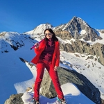
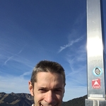
Gallery
Participants
You need to be logged in to see the participants
Weather
°
°
°
°
Description
Embrace a bold 18 km alpine loop with 1,070 m of ascent across rugged ridges and dramatic terrain—perfect for explorers seeking epic views, empowering challenge, and unforgettable moments. See https://www.komoot.com/de-de/tour/2537432206?share_token=aqJ13Hzy8tW62PkmBepliin68Z4QxIotSrsmirhQQ2Pr4K80xn&ref=wtd for the route and https://www.meteoblue.com/de/wetter/woche/schellkopf_deutschland_2839803 for the weather forecast.
Necessary: hiking boots, ⩾ 3 L of water, and a bit of food. There are no huts on the way.
This hike is unguided. Hiking is a dangerous activity. Each participant is fully responsible for himself/herself, including all the risks he/she takes; don't count on me.
In case of very few participants or harsh weather, the hike may be canceled or postponed.Comments
Irina H.
5 months ago
Hi Alex, are you still planning to do this hike? Please reply here or via WhatsApp = I don't receive emails from HB. Thanks in advance. Regards, Irina
0
|
0
Alex M.
5 months ago
Yes.
0
|
0
Alex M.
5 months ago
@Irina: Feel free to drop me a message to a_l_e_x_0 [at] ro [dot] ru if you wish to come but the formal registration deadline for you has passed.
0
|
0
Irina H.
5 months ago
Alex, I can be there 08.25, Parkplatz im Griesen, if you don't mind to start a bit later.
0
|
0
Alex M.
5 months ago
@Irina If the other hiker shows up, you'll catch up. If the other hikes doesn't show up, I'll wait.
1
|
0
Irina H.
5 months ago
OK, thanks. Then till tomorrow.
0
|
0
Alex M.
5 months ago
@Irina Great! See you at the parking lot in Griesen or on the ascent!
1
|
0
Alex M.
5 months ago
Typo in the location of the start of the hike: “entrace” -> “entrance”.
0
|
0
Irina H.
5 months ago
Good morning Alex,
I'm on the way, how about you? Are we 3 now or 2? >>> will you start at 8 exactly or will be able to wait a bit?
LG
Irina
0
|
0