Uploading...
Overall progress...
0%
File progress...
0%
Edit event: [CH] Sörenberg to Brienzer Rothorn (though Lättgässlipass)
T3 - [CH] Sörenberg to Brienzer Rothorn (though Lättgässlipass)
 Organized by:
Route
Sörenberg to Brienzer Rothorn
| Elevation gain |
| Elevation loss |
| Distance |
| Duration |
| Highest altitude |
| Rating |
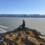
Gallery
Participants
You need to be logged in to see the participants
Weather
°
°
°
°
Description
This hike offers a scenic view over Brienzersee, and if lucky we may see Steinbocks on the way :)
----------------------------------------------
Starting point: Talstation Rossweid @ 09:00
End point: Brienzer Rothorn. From there, we will take the Luftseilbahn (15 Chf mit HalbTax) back to Sörenberg, after we still have 3 km of extra walk to get back to the starting point.
You can also hike down, here is the gpx file of the full loop: https://www.hiking-buddies.com/routes/routes_list/6822/
----------------------------------------------
Everyone should have: Hiking shoes (mandatory), poles (optional), proper clothes (please check the weather), water. Whoever is sensitive to sun should take sunscreen.
Food: Bring your own, or the restaurant at Brienzer Rothorn
----------------------------------------------
Pace: Moderate ~ 350-400m per hour
Estimated
duration: 5 - 5:30 hours (including the
----------------------------------------------
How to
arrive there:
BY Car (Parking available at Talstation
Rossweid)
or
BY
Public Transport
If you come by public transportation, click on "Carpool" and "Add Car", and add train as a car.
From Zürich HB, please take the following connection:

----------------------------------------------
Whatsapp group: https://chat.whatsapp.com/HaBdbQaEfdgKJWupLKujVK
Good to know
Safety notices
I am not a professional guide. Everybody is responsible for him/herself. Make yourself familiar with the route and its requirements. It's recommended to download the route (it can be found on this page) and bring a mobile phone / smartwatch that can read gpx files, as well a first aid kit for emergencies.
I have never done this hike before.
Comments
Marc Gou
6 months ago
Whatsapp group link: https://chat.whatsapp.com/HaBdbQaEfdgKJWupLKujVK
0
|
0