Uploading...
Overall progress...
0%
File progress...
0%
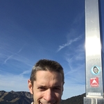
Edit event: Schrecksee, Knappenkopf, Kugelhorn, Rauhhorn
T5 - Schrecksee, Knappenkopf, Kugelhorn, Rauhhorn
 Organized by:
Route
Schrecksee, Knappenkopf, Kugelhorn, Rauhhorn
| Elevation gain |
| Elevation loss |
| Distance |
| Duration |
| Highest altitude |
| Rating |
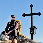
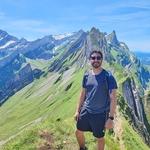
Gallery
Participants
You need to be logged in to see the participants
Weather
°
°
°
°
Description
Description
📅 Friday 3rd October | ☀️ Beautiful weather forecast | 👫 Open to all interested hikers
This alpine
hiking route is a breathtaking adventure through the Allgäu Alps, starting at
the turquoise gem Schrecksee, surrounded by dramatic peaks and lush meadows.
The trail ascends to Kirchdachsättel (1925 m), offering panoramic views over
the rugged terrain. From here, you continue to Knappenkopf (2071 m), where the
landscape opens up to stunning ridgelines and distant valleys. At Kugelhorn
(2126 m), the highest point of the route, you’re rewarded with 360° mountain
vistas—ideal for photos and a break. Descending to Hintere Schafwanne (1957 m),
the terrain softens into rocky alpine pastures. The final stretch toward
Rauhhor leads along wild, less-traveled paths with majestic scenery all around.
Weather in this region is typically crisp and clear in summer, with
temperatures ranging from 10–18°C, but can change rapidly. A mix of sunshine
and clouds adds dramatic light to the views, making this hike unforgettable.
About Car.
In my car just will go 5 person if more than 5 you can add your own car and
join than other members join you in your car .
📍 Plan for the Day
🚗 Meeting & Pickup Point:
Feldmochinger Str. 216, 80995 München S bahn Station parking or Edeka
We’ll carpool from here, please be on time.
👉 Google Maps Link
05:30
AM – Feldmochinger Str. 216, 80995 München S bahn Station parking or Edeka
07:30 AM –Breakfast and ready time to start hike
07:50 to 08:00 AM- Parking "Auf der
Höh" Begin hike from Parking "Auf der Höh"
to Schrecksee , Kirchdachsättel 1925m,Knappenkopf 2071m, kugelhorn 2126m,
Hintere Schafwanne 1957m, Rauhhor 2240m, Vordere Schafwanne 2055m
11:00 AM – Summit reached, enjoy
panoramic views Schrecksee Than go till last point
15:00 PM – Reached Vordere Schafwanne 2055m
15:45 PM – Return to
Parkplatz
18:00 PM – Reached Parking "Auf der Höh and go back
to München
20:00 PM – Approximate arrival at Karlsplatz, 80999
München S bahn Station parking
🎒 What to Bring
- Snacks (optional, breakfast and
lunch as planned above)
- Plenty of water – it will be a warm,
sunny day
- Cash – some mountain
huts don’t accept cards
- Hiking
shoes (essential)
- Hiking poles (optional)
- Expacted Snow
- Warm layer Clothes tem Around 8 to 14 and Cold wind
- Good vibes and team spirit! 😊
This is a
friendly group hike, and we aim to keep the group together and
enjoy the experience as a team.
------------------------------------------------------------------------------------------------------------------------------------------------------
Good to know
⚠️ Disclaimer
This is not a guided tour. I’m simply organizing and sharing the plan. Everyone is responsible for their own safety and participation.
*Legal Disclaimer**
I am not a guide. Everybody is responsible for themselves. Make yourself familiar with the route and its requirements. The organizer holds no responsibility for any injuries or death that might result directly or indirectly from this event. The organizer does not warrant the accuracy of the description of the event. By joining the event, you accept the terms explained above. Please be aware that you join at your own risk.
Please read the following carefully before participating in the hike:
1. **Not a Guided Tour**: This hike is not a guided tour. I am only facilitating the organization of transportation to the starting point for like-minded, qualified, properly equipped, and reliable individuals.
2. **Self-Navigation**: Each participant is responsible for navigating themselves on the suggested route. You must have the necessary skills, experience, and equipment to independently complete the hike.
3. **Acknowledgement of Risk**: By joining this hike, you acknowledge that hiking can be dangerous. You understand and accept the inherent risks involved.
4. **Personal Responsibility**: You are fully responsible for your own safety and well-being during the hike. This includes being prepared for all weather conditions, having adequate supplies, and ensuring your physical readiness for the hike.
5. **Insurance**: You confirm that you have sufficient insurance coverage, such as membership with the German Alpine Club (DAV), Mountain Rescue Service (Bergrettung), or a similar organization. This insurance should cover any potential accidents or emergencies that may occur during the hike.
By participating in this hike, you agree to release the organizer from any liability for injuries, accidents, or other incidents that may occur. You participate at your own risk and responsibility.
If you decide to leave the group (go in front by yourself, or stopping for no reason), then we won’t search for you and you officially left the group, it is also the same if you don't bring required gears
Comments
Alex M.
5 months ago
I'm going to skip breakfast and drive directly (with a small break) from the southwest of Munich to the parking lot “Auf der Höh”; same for whoever decides to travel with me.
0
|
0
Shakeel Danish
5 months ago
ok perfekt
0
|
0
Gianfranco Borgetto
5 months ago
Good morning everyone! I'm already at the meeting point 😄
0
|
0
Shakeel Danish
5 months ago
i will be there just 5 minuts
0
|
0