Uploading...
Overall progress...
0%
File progress...
0%
Edit event: Schinder via Schindertor
T4 - Schinder via Schindertor
 Organized by:
Route
Schinder via Schindertor
| Elevation gain |
| Elevation loss |
| Distance |
| Duration |
| Highest altitude |
| Rating |
Gallery
Participants
You need to be logged in to see the participants
Weather
°
°
°
°
Description
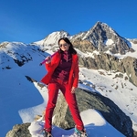
🎃 Halloween Hike 🎃 to the Schinder
The weather supposed to be beautiful🌞—and hopefully not too much snow on the trail. And yes: this hike wasn’t picked at random—just check the German dictionary for the meaning of the word “Schinder”.
I still have no idea how to generate routes here properly, so I’ll describe the route old-school: Valepp Forsthaus Parkplatz → Schinder Kar/then Schinder Tor → Bayerischer Schinder → Österreichischer Schinder → Trausnitz Alm → Valepp Forsthaus Parkplatz.
We’re going by car: petrol and parking costs will be shared (and don’t forget to bring an extra pair of shoes).
Meeting point: Giesing Bhf at 7am.
Please text in the event chat!!!
Read the tour description carefully, it's not a beginner friendly tour!!!
(https://www.tourentipp.com/de/touren/schinder-bergtour-tegernsee_215.html), watch a few videos (there are plenty on YouTube), and join only if you’re comfortable with the route. We’ll bring Grödel/spikes just in case (especially for the Schinder Kar).
Disclaimer: Bergsport can be dangerous. I am not a mountain guide and don't even pretend to be. Everybody is responsible for themselves. Please make yourself familiar with the route and its requirements. Additionally, you could download the map and bring a cell phone and a first aid kit.
***
The hike description from one of Hiking Buddies (who's route I'm copying):
This is the most scenic route to both Schinder peaks. Ascent via Schinderkar through Schindertor (a tunnel with a short T4 section with steelropes and steel pins, see pictures)
Schinder is a twin peaked mountain, located on the border between Germany and Austria. Indeed, its two summits, which are separated by a distance of some 700m, are located on opposite sides of the border. The lower western summit, Bayerischer (Bavarian) Schinder reaches 1796m, while the higher eastern summit, Östereichischer (Austrian) Schinder (also Trausnitzberg) reaches 1808m. Thanks to its location and depending whom you ask, the mountain also appears to belong to two mountain ranges: the Bavarian Prealps or the Rofan / Mangfallgebirge. As the higher summit is on Austrian ground most likely the latter definition is most likely correct and is used by most authors.
While Schinder surely cannot be called a high mountain, nevertheless it stands out among its neighbours. This is mainly due to the fact that it is a solitary mountain, not connected by any ridge to any of its neighbours. More important, however, is the fact that its two summit bear a dolomite ressemblance, especially when seen from the north. Schinder is a limestone mountain and the steep faces as well as the huge scree fields bear witness to that fact.
To the north the two summits with their ridges form a horseshoe-like cirque: Schinderkar. Here you can find the biggest scree slope of them all, which comes down from the saddle between the summits. While it is mostly used for descent only - difficult enough in the upper section - it also forms a good winter ski tour route. From my own experience I can only warn to do it in summer conditions. The whole scree field is constantly shifting and there are few places with firm ground underneath. The main attraction of this route, however, is the rock window at its top, a bit underneath the saddle. Here the route is protected by cables and worn ropes as well as pins to scale the steepest sections. The final ascent follows the west ridge of Östereichischer Schinder and is also protected by cables in several places.
The ascent over the Schinderkar is exhausting but very beautiful, it is also possible to do the tour the other way round.
Good to know
Please text in the event chat or per WhatsApp!
And arrive to the meeting point punctual or 10 minutes earlier (the driver will appreciate that).
Comments
Irina H.
4 months ago
Hi Fernando,
Ive kindly asked to text hier before you join event. Are you sure that you will be able to do this hike? There's quite challenging ascent, then via ferrata on the way to the first peak and the ridge way to the second one. And both of us going quite fast FYI.
Regards,
Irina
0
|
0
Irina H.
4 months ago
Dear Fernando,
I hope you’re doing well. Unfortunately, I haven’t received any reply from your side. I’m not judging your mountain experience, but I did notice that I couldn’t find any hikes listed on your profile—it looks like a Tabula rasa.
Because the upcoming tour isn’t beginner-friendly and requires the right equipment and experience (especially given that trail conditions are already far from ideal), I’m afraid I must remove you from the carpool for this event.
I’m sorry about that. I hope we’ll have the chance to hike together in the future once the terms and conditions are met.
Warm regards,
Irina
0
|
0
Irina H.
4 months ago
Good morning Fernando,
in case you are coming: I have already met with my friend and we are chatting in the car. Please update about your location. Text here only.
Regards,
Irina
0
|
0