Uploading...
Overall progress...
0%
File progress...
0%
Edit event: Schinder
T4 - Schinder
 Organized by:
Route
Schinder via Schindertor
| Elevation gain |
| Elevation loss |
| Distance |
| Duration |
| Highest altitude |
| Rating |
Gallery
Participants
You need to be logged in to see the participants
Weather
°
°
°
°
Photo & Film Consent:
Participants of this event consent to being photographed and/or filmed.
Description
Hike to Austrian and Bavarian Schinder.
WhatsApp group: https://chat.whatsapp.com/DNQsqIBy1NF7z57s2NE4rA
Technical Difficulty: This hike is NOT suitable for complete beginners. Previous hiking experience necessary to join (contact me with your experience if you have a new profile or I reserve the right to remove you). You have to be surefooted. You should have experience with easy scrambling, and not be slow (>=400m gain/hour).
Weather conditions: weather forecast is currently clear and sunny, prone to changes in the last minute (hike will be confirmed Friday afternoon depending on forecast).
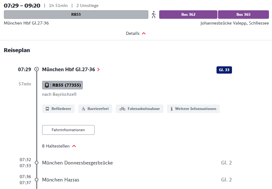
Transport: we will take public transport to get there. Train RB55 till Schliersee --> Bus 362 till Spitzingsee --> Bus 365 till Johannesbrücke, Valepp (start point). Train leaves Hbf at 07:29 from Pl. 33, Harras 07:35 from Pl. 2 (I will be joining at Harras). Feel free to get on the train wherever is more convenient!
Things to bring:
- proper hiking shoes
- hiking poles
- food and water for the day
- swimwear for the lake (Schliersee on the way back)
- appropriate clothing according for the weather
- GPX viewer with the route information
- cash because cash is king
Good to know
Legal disclaimer: This is not a guided tour. I am merely organizing the trip to the starting point with like-minded, qualified, properly equipped and reliable persons. Each participant is responsible for navigating themselves on the suggested route. You must have the necessary skills, experience, and equipment to independently complete the hike. By joining this hike, you acknowledge that hiking can be dangerous, and understand and accept the inherent risks involved. You are fully responsible for your own safety and well-being during the hike. This includes being prepared for all weather conditions, having adequate supplies, ensuring your physical readiness for the hike, and having sufficient insurance coverage, such as membership with the German Alpine Club (DAV), Mountain Rescue Service (Bergrettung), or a similar organization. This insurance should cover any potential accidents or emergencies that may occur during the hike. By participating in this hike, you agree to release the organizer from any liability for injuries, accidents, or other incidents that may occur. You acknowledge that you are participating at your own risk and responsibility.
Comments
Prayag Miskin
1 month ago
WhatsApp group: https://chat.whatsapp.com/DNQsqIBy1NF7z57s2NE4rA
0
|
0
Prayag Miskin
1 month ago
Pl check your spot on the list and join the WhatsApp group if confirmed for the hike, there are many people on the waiting list as well
0
|
0
Prayag Miskin
1 month ago
Please carry food and LOTS OF WATER, it will be a very hot day!!! I will be stopping at Schliersee on the way back. Others are welcome to join if they wish.
0
|
0

Oliver Watkins
1 month ago
Unfortunately my plantar fasciitis is flaring up so I'll have to unjoin. Enjoy. It's an amazing hike
1
|
0

Elnaz
1 month ago
I am also dropping due to the weather. wish you a nice day
0
|
0
Prayag Miskin
1 month ago
Temperatures keep rising and rising, shifting hike to prevent meltdowns!
0
|
0