Uploading...
Overall progress...
0%
File progress...
0%
Edit event: [CH] 3 Days on Schwarzwald Westweg Stage 9 to 7
T1 - [CH] 3 Days on Schwarzwald Westweg Stage 9 to 7
 Organized by:
Route
Schwarzwald Westweg Etappe 7 to 9
| Elevation gain |
| Elevation loss |
| Distance |
| Duration |
| Highest altitude |
| Rating |
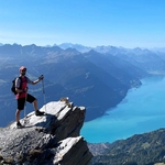
Gallery
Participants
You need to be logged in to see the participants
Weather
°
°
°
°
Description
Three-day trekking event tackles the legendary Westweg (West Way) in reverse, traversing Stages 9 through 7. This high-altitude route follows the main ridge of the Black Forest, offering nice views across the Rhine Valley to the Vosges Mountains.
Technical Logistics & Setup
Strategy: We park the at the finish in Hausach to ensure total flexibility on Day 3 and take the morning train from Hausach to Hinterzarten. You can come by train from Zurich directly to Hinterzarten Hbf, a train combo from Zurich HB at 06:59 and arrives in Hinterzarten Hbf at 9:43.
Transit Duration: ~1h 58min to 2h 20min (1 transfer in Villingen).
Terrain Profile: Primarily wide forest tracks, some rocky single-track (Root/Stone factor: Moderate), and soft forest floor.
Waymarking: Follow the Red Diamond (Rote Raute) symbol.
Itinerary
Day 1 ===== Stage 9 (Reversed): Hinterzarten → Kalte Herberge
Beginning in the high-moor landscape of Hinterzarten, the trail climbs the northern ridge overlooking the Titisee basin.
Distance: ~20.2 km
Ascent: 580 m | Descent: 320 m
Night 1 Stay: Gasthaus Kalte Herberge
Free rooms are still available
Day 2 ===== Stage 8 (Reversed): Kalte Herberge → Wilhelmshöhe
A classic ridge-line trek passing through the "High Forest" with rolling elevation changes.
Distance: ~22.4 km
Ascent: 460 m | Descent: 510 m
Technicality: Low steepness, high endurance requirement due to distance.
Night 2 Stay (Schonach area): Hotel Bergfreiheit
Accommodation located ~2.5 km off-trail in Schonach,
- Free rooms are still available at the same location or you can find something else in the village.
Day 3 ===== Stage 7 (Reversed): Wilhelmshöhe → Hausach
A demanding final stage. After a scenic ridge walk, the trail features a massive technical descent into the Kinzig Valley.
Distance: ~21.3 km
Ascent: 440 m | Descent: 1,150 m
Gradient: Significant negative grade in the final 5 km (Hard on knees).
Finish: Arrive at the car at the Hausach Bahnhof.
The Grand Finale
After reaching your car in Hausach, drive 55 km (~1 hour) back to Titisee for professional muscle recovery.
Final Stop: Badeparadies Schwarzwald
Facilities: 12 themed saunas, 18+ pool environments, and mineral-infused lithium/calcium baths.
Access: 10-minute walk from Titisee Station/Parking, opened until 10PM.
Summary Table
| Metric | Total Value |
| Total Distance | ~64 km |
| Cumulative Ascent | 1,480 m |
| Cumulative Descent | 1,980 m |
| Fitness Level | T2/T3 (Mountain Hiking Scale) |
Good to know
Whatsapp group: https://chat.whatsapp.com/GnpFMw3JSmsAjp6x6JcZuR?mode=gi_t
Comments
Botond Kovács-Nüszl
2 months ago
"high-altitude route" :D
Why is ca. 1000 hm difference between the map and the ascent in the summary table?
2
|
0

Dragoş Roşu
2 months ago
the Gpx starts from a different location as from the plan. I did not update the GPX to reflect the Summary table. Anyway, that 800m difference is peanuuts.
0
|
0