Uploading...
Overall progress...
0%
File progress...
0%
Edit event: [CH] [1200 elevation gain] Bogartenlücke, Saxerlücke & 2 lakes
T2 - [CH] [1200 elevation gain] Bogartenlücke, Saxerlücke & 2 lakes
 Organized by:
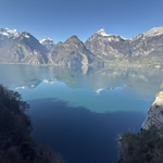
Route
Bogartenlücke, Saxerlücke, Fälensee, Sämtisersee
| Elevation gain |
| Elevation loss |
| Distance |
| Duration |
| Highest altitude |
| Rating |
Gallery
Participants
You need to be logged in to see the participants
Weather
°
°
°
°
Photo & Film Consent:
Participants of this event consent to being photographed and/or filmed.
Description
Ladies and Gentlemen,
Hereby I present my hike for Saturday.
Hiking highlights: Bogartenlücke, Saxerlücke, Fählensee, Sämtisersee
Those who want to come by public transport should create or join a virtual car in the carpool.
Snow condition: The route should be free of snow
Start point: Wasserauen (https://maps.app.goo.gl/BYZFo9caFUwLpLqr8)
End point: Brülisau, Kastenbahn (https://maps.app.goo.gl/vNJwdW2mH2m663TC9)
How to arrive there (from Zurich HB):
07:08 Zurich HB (Platform 10) -> 08:21 Gossau SG (Platform 11) --> Wasserauen
Elevation gain and loss: around 1200 m
Highest point: 1760 m
Pace: Moderate (around 400-500m of elevation gain per hour, one should be in a good physical shape)
Everyone should have: Hiking shoes, proper clothes, food, water, sunscreen.
I might cancel or reschedule the event in case the weather deteriorates by Saturday
Important: Download the .gpx file and load it into a proper app (Swisstopo, Atlas...). If the file fails to load into the app, try renaming it and setting the extension to .gpx.
Link to the whatsapp chat: https://chat.whatsapp.com/J0UhLGkL8SDFREwUX6QaeN
Optional: The very fit people can do a detour and go through the ridge to Stauberenkanzel. It is also possible to go swimming in Sämtisersee.
Everyone participates at their own risk. In the event of injury or death, I accept no liability.
Best regards
Comments

Sergii Yatsuk
1 month ago
hi, are you aiming to start at 9:15? It seems like train time is incorrect. I cannot find such connection.
0
|
0

Atanas Bayraktarov
1 month ago
Good job noticing this. I corrected the information in the description. The train from Zürich Hauptbahnhof departs at 07:08. Best regards.
1
|
0
Zhiyang He
1 month ago
Ladies and gentlemen *
0
|
0

Michele
1 month ago
The above mentioned optional way back route is this one:
https://www.hiking-buddies.com/routes/routes_list/7401/
I will do it from Saxerlücke, feel free to join me. The organizer Atanas has already been informed about that.
0
|
0

Chris Bona
1 month ago
Unfortunately I can’t come and also can’t remove car from carpool to cancel 🥲
0
|
0