Uploading...
Overall progress...
0%
File progress...
0%
Edit event: [CH] [1250m elevation gain] Morgenberghorn Summit Tour
T3 - [CH] [1250m elevation gain] Morgenberghorn Summit Tour
 Organized by:
Route
Route to the Morgenberghorn
| Elevation gain |
| Elevation loss |
| Distance |
| Duration |
| Highest altitude |
| Rating |
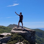
Gallery
Participants
You need to be logged in to see the participants
Weather
°
°
°
°
Photo & Film Consent:
Participants of this event consent to being photographed and/or filmed.
Description
Ladies and Gentlemen,
Hereby I present my hike (T3) for Saturday.
Highlights: Greberegg, Morgenberghorn. View upon Thunersee and Brienzersee.
Those who want to come by public transport should create or join a virtual car in the carpool.
Start and end point: Aeschiried, Schulhaus (https://maps.app.goo.gl/gMTzR15xAs1osNr76)
How to arrive there (from Zurich HB):
07:02 Zurich HB -> 08:38 Spiez --> Aeschiried, Schulhaus (1h:52min travel time)
Elevation gain and loss: around 1250 m
Highest point: 2248 m
Pace: Moderate (around 400-500m of elevation gain per hour, one should be in a good physical shape)
Everyone should have: Hiking shoes, proper clothes, food, water, sunscreen.
I might cancel or reschedule the event in case the weather deteriorates by Saturday
Important: Download the .gpx file and load it into a proper app (Swisstopo, Atlas...). If the file fails to load into the app, try renaming it and setting the extension to .gpx.
Link to the Whatsapp chat: https://chat.whatsapp.com/DMKVCPr8lpG2y8i82h3lPp
Everyone participates at their own risk. In the event of injury or death, I accept no liability.
Best regards
Comments
lingo
1 week ago
it is a very pity that in order to participate to this event, one should by default consent to being photographed and/or filmed. The norm should be the way around.
It is a pity as the event looked nice.
Anyway, enjoy everyone.
0
|
0
Atanas Bayraktarov
1 week ago
We are taking photos. You could stay away from the group photos. But I cannot guarantee that by accident you don't end up on one of them. Have a good evening
0
|
0