Uploading...
Overall progress...
0%
File progress...
0%
Edit event: Lenggries to Stie-Alm via Brauneck
T2 - Lenggries to Stie-Alm via Brauneck
 Organized by:
Route
Lenggries to Stie-Alm via Brauneck
| Elevation gain |
| Elevation loss |
| Distance |
| Duration |
| Highest altitude |
| Rating |
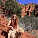
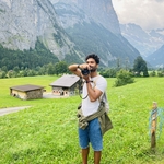
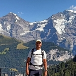
Gallery
Participants
You need to be logged in to see the participants
Weather
°
°
°
°
Description
A bit spontaneous, weather looks nice & here's a plan for Brauneck.
Brauneck (1,555 m) is one of the most visited peaks in Bavarian Prealps. Brauneck area is fully developed by farm tracks and the Brauneck-Bergbahn as well as several ski lifts and is a popular skiing and hiking area due to its proximity to the state capital Munich (60 km) and the connection to the Bayerische Oberlandbahn (BOB).
Ascent: The hike is easy and well-marked.
Descent: Same as ascent (variations possible).
Webcam: https://www.brauneck-bergbahn.de/webcams/
| Technical Difficulty | Medium | |||||||||||
|---|---|---|---|---|---|---|---|---|---|---|---|---|
| Gear | Hiking Boots, Hiking Poles | |||||||||||
Good to know
We will move at a moderate pace (no speed hiking or running).
Things to Bring: -
- Hiking shoes.
- Food and water (2-3 litres) - there is one hut along but still better to have some food :)
- Good mood and energy :)
Optional:
- Trekking/hiking poles.
- Sunglasses/protection and sunscreen.
We will be meeting on nearby platform 30-33 in MUC Hbf 7.55,
We have our quick know-each-other time and find our seats together, might be train could be packed.
We will take the train back to Munich at ~15:47 or 16:11! (Tentative for now) WA - 015171947527
Note: Please unjoin the event asap if you can't participate anymore.
Disclaimer: Hiking Buddies Munich is not a group of professional mountain guides but individuals gathering for sports activities. Each participant is responsible for her-/ himself and has to be prepared, bring suitable equipment, and check if he meets the physical requirements. Hiking includes a particular risk and everybody is responsible for his/ her own safety. It is highly recommended to have some insurance in case of an incident.
Comments
Rossella Giardi
1 week ago
Hi everyone! FYI I will get on the RB56 at Harras
1
|
0
Soumya D
1 week ago
Hey all GM, Weather changing slightly it's good have a rain jacket packed if you haven't started see you soon
0
|
0

Yannis Krontiris
1 week ago
hi, which train we are targeting?
0
|
0
Yannis Krontiris
1 week ago
oh sorry, on the mobile interface I was not able to see the information above
0
|
0
Soumya D
1 week ago
it's 08.02 RB 56 Lenggries -
0
|
0

Jeff Lynn
1 week ago
It‘ll be tight for me. I don’t get in until 7:58! I may have to catch the 8:29 and try to catch up.
0
|
0
Yannis Krontiris
1 week ago
I am already there
0
|
0

Raza
1 week ago
I am also here
0
|
0
Soumya D
1 week ago
reaching 2min
0
|
0
Soumya D
1 week ago
Platform 32 - RB56
0
|
0
Soumya D
1 week ago
First compartment of the train
0
|
0
baljeet .
1 week ago
I am already inside.
1
|
0
Jeff Lynn
1 week ago
where did everyone get to?
0
|
0
Soumya D
1 week ago
Hey 👋🏻 I hope you doing great and had e good start to the week, thankyou so much once again for joining the hike. I have added the picture and feel free to do so if you have some, additionally I have added the reviews for all of you but there was some slight glitch on the android version of the app so wrote to Amit it would be updated. See you in another one :)
1
|
0