Uploading...
Overall progress...
0%
File progress...
0%
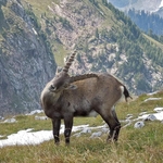
Edit event: Fockenstein [16.2 Km, 1090 m gain]
T3 - Fockenstein [16.2 Km, 1090 m gain]
 Organized by:
Route
Lenggries - Geierstein - Fockenstein - Bad Wiessee
| Elevation gain |
| Elevation loss |
| Distance |
| Duration |
| Highest altitude |
| Rating |
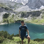
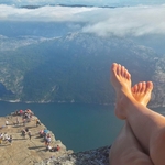
Gallery
Participants
You need to be logged in to see the participants
Weather
°
°
°
°
Description
Fockenstein in Mangfallgebirge is a classic peak in summer as in winter. Even though not too deep into the alps the scenery I going to be stunning on a nice sunny Saturday ;)
Credit Photo: hoehenrausch.de
Be prepared for deeper snow and cold breezes; bring appropriate equipment and clothing.
Please bring lunch and drinks; we will have a longer break at the peak.
Please read all the sections below carefully and completely!
Good to know
Transportation
The meeting point is in front of platform 34 of München HBF by 7:45. We will travel on a Bayern Ticket (group ticket) which I will buy on-site by this time; if you are late you will have to buy your own one. The cost is depending on the number of participants but should be around 12€. You can pay by either cash (please bring coins) or paypal.me/vincenthessfeld (working PayPal account associated with a bank account required).
Train schedule:
Munchen HBF 8:04 – 9:04 Gmund (Tegernsee) – 9:11 Kogelkopfstraße (Bus 9559), Bad Wiessee
Lenggries 17:17/ 17:47– 18:32 / 18:54 Munchen HBF
Equipment
The following is a list of recommended equipment:
· Proper hiking boots
· Head lamp
· First aid kid
· Water (2l)
· Hiking poles
· Waterproofs (jacket, trousers, bag cover)
· Gaiters
· Crampons
· Warmth
· Hat and gloves
· Sun glasses and sun cream
· ID Card/ passport
· Phone (for emergency calls)
· Map (digital or print out of the route)
Note
Please be aware that you are not able to withdraw from the hike later than 12h before the starting time. Please be fair and give your spot to other hikers if you are not able to come. If you are new to Hiking Buddies and do not have at least 2 reviews in your profile, please give me a short notice about your past hiking experience via Hiking Buddies Messenger until two days before, 24:00 o’clock. Otherwise I am going to remove you from the hike. This is not to blame you but to ensure that you have the physical fitness and everybody can enjoy the hike.
Disclaimer:
Hiking Buddies Munich is not a group of professional mountain guides but individuals gathering for sport activities. Each participant is responsible for her-/ himself and has to be prepared, bring suitable equipment and has to check if he meets the physical requirements. Hiking includes a certain risk and everybody is responsible for his/ her own safety. It is highly recommended to have some kind of insurance in case of an incident.
Comments
Andrea
6 years ago
Please change your route. Your version leads through a protected area.
1
|
0
Vincent
6 years ago
I cannot find any information that there is a path being closed due to wild life protection and this is a common route... If there is any sign on the way we will adapt our route.
0
|
0
Julia
6 years ago
Your route on map starts in Bad Wiesse and ends in Lengries : one way route 16 km, but in description you write , that it ends as well in Bad Wiesse: are you going to turn from Lengries back to Bad Wiese and make 32 Km route ? :))
0
|
0
Vincent
6 years ago
Oh, you're right. Plan is from Lenggries to Bad Wiessee. Will change this!
0
|
0
Vincent
6 years ago
I will update the route later! We will go from Lenggries to Bad Wiessee. So we will take a train to Lenggries in the morning.
1
|
0
Vincent
6 years ago
But meeting time and place in the same. It's the BOB which divides in Holzkircheb
0
|
0
Vincent
6 years ago
Updated! Final plan above
0
|
0