Uploading...
Overall progress...
0%
File progress...
0%
Edit event: Panoramic ridge hike Sollereck-Fellhorn [19.5 Km, 1320 m gain]
T3 - Panoramic ridge hike Sollereck-Fellhorn [19.5 Km, 1320 m gain]
 Organized by:
Route
Panoramic ridge hike Sollereck-Fellhorn
| Elevation gain |
| Elevation loss |
| Distance |
| Duration |
| Highest altitude |
| Rating |
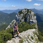
Gallery
Participants
You need to be logged in to see the participants
Weather
°
°
°
°
Description
Dear buddies. I was too long without organizing a hike in this wonderful group! Altough at the moment the max group size is very small, still I want to give the possibility to people to join for a very lovely hike together. I want to have a full day experience like in the good old times, so long trip, long beautiful hike and maybe also dinner together to enjoy as much as possible the day and have the closest as possible experience to normality. In the meantime let´s make the best out of the times we live and let´s spend a great day together!
A beautiful ridge hike south direction between Söllereck and Fellhorn offers us great views of the Allgäu Alps. The mountain Söllereck separates the Austrian Kleinwalsertal from Stillachtal. Once left Oberstdorf village on our back we follow the hiking trail to Freibergsee. The view of the mountains that rise above the deep blue water is simply fantastic. The hiking trail leads you from the lake through a light forest to the valley station of the Söllereckbahn. Glades and forests alternate on the subsequent ascent. At the top a great view of Oberstdorf awaits you. From Hochleiten (1170), in wide loops with many flat passages, we continue on a wide path along the beautifully made nature trail and it takes a long time until "Fellhorn" is finally signposted as the destination. From the Sölleralpe it goes well uphill and after another quarter of an hour we stand on the Fellhorngrat and thus we have a great view towards Kleinwalsertal for the first time. We reach few summits one after each other: first Schlappoltek and Söllerkopf and then Schlappoldkopf. We will definitely take a break to enjoy views here. The further hiking trail is pure joy: beautiful views in all directions. The continuation of the path is not demanding and again very promising and extremely rewarding, if you also have taste for the views. We finally reach Fellhorn cross. We take a break here and we then go down to Schlappoldsee on the way down to the valley.
Disclaimer: Hiking can be dangerous. I am not a mountain guide. Everybody is responsible for her/himself. Make yourself familiar with the route and its requirements. It's recommended to download a map and bring a cell phone for emergencies.
Good to know
Things to bring:
- Hiking boots
- Water
- Food/drinks for the way
- Appropriate clothes for a hike
-charged mobile phone with rescue number saved 112 and my number 017643285424
Cash for the ride
Passport/ID
Headlight (just in case)
Sunscreen
Comments
Thomas T.
5 years ago
note: you must wear a mask all the time in public transport, even on the platform
4
|
0

Marco Mecarozzi
5 years ago
Sure. This Is something that everyone should be aware of.
1
|
0
Marco Mecarozzi
5 years ago
To those coming: Please, given the small amount of people allowed this weekend still, be responsible and If you think you cannot make It let your Place to others and unjoin very worst case 12 h before event. Thanks for understanding.
2
|
0
Emma-Lee Knape
5 years ago
I’m looking forward to hiking together again soon Marco! Thanks for organising another hike 😀
1
|
0
Reza Mortazavi
5 years ago
how can i put myself on the waiting list?
0
|
0
Marco Mecarozzi
5 years ago
Waiting list Is full. If any Place gets free then you Will be able to add your name.
0
|
0