Uploading...
Overall progress...
0%
File progress...
0%
Edit event: Zigerstein [12.7 Km, 1008 m gain]
T3 - Zigerstein [12.7 Km, 1008 m gain]
 Organized by:
Route
Zigerstein
| Elevation gain |
| Elevation loss |
| Distance |
| Duration |
| Highest altitude |
| Rating |
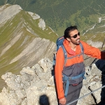
Gallery
Participants
You need to be logged in to see the participants
Weather
°
°
°
°
Description
We are crossing the border, so please bring your passport (or other document that you usually carry for border crossing)
This is an easy-medium hike - The only challenging part of the hike is from Schaertle to Zigerstein, however it is possible to skip this part, as we will come back to Schaertle from the peak. The hike ends in Heiterwanger See, so it is possible to swim in the lake after hiking.
Public transport: We will take RB5512 departing at 8:32 am from platform 27, and arrive Bichlbach Almkopfbahn at 10:45 am. This is the start point of the hike. The hike ends in Heiterwang-Plansee
Departure time of return connection: 16:36 (2h11m), 17:11 (2h15m), 18:36 (2h11m), 19:11 (2h15m)
Technical difficulty: The hike has difficulty T3. Please read the blog to understand the requirements for sac scale T3.
There are no huts on the way, so please bring enough food/drinks for the whole day to avoid starvation/dehydration.
Things to bring:
- Waterproof hiking boots
- Cash for the ticket (10-12 EUR)
- Food/drinks for the way
- Sunscreen
- Swimming clothes, if you are interested in checking water temperature
- Some tolerance for cloudy and rainy weather
Note: Please unjoin the event well in advance, if you don't plan to come. You cannot unjoin the event, when it is starting in less than 12 hours.
Disclaimer: I am not responsible for you, if anything happens to you.
Comments
Sina Jahanbakhsh
5 years ago
Hi! Can I just show up Sunday morning, or I must have registered beforehand?
0
|
0

Ajay Verma
5 years ago
You need to register beforehand. At this point this event is already full, so you can join only if enough people drop out, if not then hope to see you in future events! Btw, if you are interested, there is another hike happening on the same day, which still has free spots: https://www.hiking-buddies.com/routes/events/2109/
2
|
0
Sina Jahanbakhsh
5 years ago
Thanks for the answer. I am new, so maybe I asked a silly question :D see you soon!
0
|
0
Ajay Verma
5 years ago
No worries! Have a nice hike, and see you next time in mountains.
0
|
0