Uploading...
Overall progress...
0%
File progress...
0%
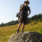
Edit event: Fellhorn (Chiemgau) [21.2 Km, 1055 m gain]
T2 - Fellhorn (Chiemgau) [21.2 Km, 1055 m gain]
 Organized by:
Route
Fellhorn (Chiemgau)
| Elevation gain |
| Elevation loss |
| Distance |
| Duration |
| Highest altitude |
| Rating |
Gallery
Participants
You need to be logged in to see the participants
Weather
°
°
°
°
Description
Long but fairly easy hike. We go by car from Goetheplatz. Gas will split by the number of passengers. We go to Seegatterl. From there we start our hike.
Ascent: The route is very long, but mostly on the mountain roads, which are not too steep. One thing to consider is that many signposts along the route only show the huts, and not the peak Fellhorn, so just believe at the gpx track and follow it.
The steep part starts at Straubingerhaus, and once you reach the saddle point, the peak is already visible. After a couple of ups and downs, the peak can be reached from there.
From the summit, you can enjoy the nice view of almost all peaks in Chiemgau alps.
Descent: Almost the same as ascent except a detour near the top, This detour could be useful as it passes through Hindenburghütte where we stop for some drinks and food for you while I have to get some introduction to hut nearby that I rented for a couple of days in August. This break may last 45min - 1h.
Then on back to the car and back to Munich Goetheplatz.
Good to know
This tour is not difficult but long.
Things to bring:
Protection mask
Hiking shoes
Food and water (2-3 liters) - there are some huts along the way where we can eat/drink something;
Trekking/hiking poles;
Good mood and energy
Pack bathing things, just in case...
Optional:
First aid kit.
Sunscreen
Disclaimer: Hiking can be dangerous. I am not a mountain guide. Everybody is responsible for her/himself. Make yourself familiar with the route and its requirements. It's recommended to download a map and bring a cell phone and first aid kit for emergencies.
Comments
Daniel J. S.
5 years ago
We meet in front of Hans im Glück right next to the cinema and McDonald's
0
|
0