Uploading...
Overall progress...
0%
File progress...
0%
Edit event: Adlerweg from Kufstein to Swimming at Hintersteiner See Beach (Strandbad) [14.0 Km, 1069 m gain]
T2 - Adlerweg from Kufstein to Swimming at Hintersteiner See Beach (Strandbad) [14.0 Km, 1069 m gain]
 Organized by:
Route
Adlerweg from Kufstein to Swimming at Hintersteiner See Beach (Strandbad)
| Elevation gain |
| Elevation loss |
| Distance |
| Duration |
| Highest altitude |
| Rating |
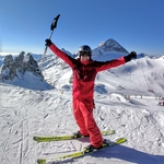
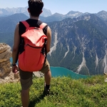
Gallery
Participants
You need to be logged in to see the participants
Weather
°
°
°
°
Description
Route: Hike starting in Kufstein, with a gorgeous view of the Wilder Kaiser as we cross a large meadow to lunch at an alm and then ultimately we will finish at the swimming lake.
The route itself is non-technical. However, it still has 1069m of elevation gain and it's probably a little too long for a first time hike. We'll hike at a moderate pace, 450m/hr, which is slightly faster than the times in a Rother guide.
Gear: A good pair of hiking boots, a sun hat, sunscreen, bathing suit and towel. Poles are optional, but always helpful. I would recommend to take max. 1 liter of water, and some snacks. There will be multiple alms with water sources along with the route. We will also stop for lunch, likely at the Kaindlhuette. You should bring cash for lunch and also a few Euros for entry at the beach. Also, we are crossing the border into Austria, so please don't forget your ID/passport.
Schedule: We will meet at Muenchn Hbf Gls 5-10 (The south side of the train station), where the trains to Kufstein and Salzburg leave from. We will arrive at Kufstein at 9am and should arrive at the Kaindlhuette at 12 noon. I expect that we will arrive at the swimming lake at 15:00 and from there, it is possible to return to Kufstein Hbf with public transit. I expect that we will be back in Munich no later than 21:00, if we spend a few hours swimming.
Good to know
Hiking Buddies Munich is not a group of professional mountain guides but individuals gathering for sport activities. Each participant is responsible for her-/ himself and has to be prepared, bring suitable equipment and has to check if he meets the physical requirements. Hiking includes a certain risk and everybody is responsible for his/ her own safety. It is highly recommended having some kind of insurance in case of an incident.
Comments

Carmen Salt
5 years ago
can I bring a friend along ?
0
|
0
Eric Mansfield
5 years ago
Yes! but please have them register via the site so that a spot can be reserved.
0
|
0

Natalie Zed
5 years ago
Hi! I am near gleis 5-10 and I do not see anybody. Am I doing smth wrong?
0
|
0
Eric Mansfield
5 years ago
We are waiting at the end of the Gleis next to the Vietnam Airlines sign.
0
|
0
JC Ramon
5 years ago
The Sbahn at Stachus is not working and I had to improvise. Arriving ca. 7:38
0
|
0
Error 404
5 years ago
Did you already go?
0
|
0
Carmen Salt
5 years ago
i missed my s bahn and won't make it anymore
0
|
0
JC Ramon
5 years ago
Where are you guys?
0
|
0
Eric Mansfield
5 years ago
We are on the train
0
|
0
Error 404
5 years ago
I am coming.please wait
0
|
0
Error 404
5 years ago
How can Ibodentify you haha
0
|
0
Eric Mansfield
5 years ago
Hi Erik. We left on the 7.43 train. If you want to catch up with us, you could take a later train and use the Kaiserlift to meet us at lunch.
0
|
0
Error 404
5 years ago
Wow, I will try with another group...Sorry guys.have fun
0
|
0