Uploading...
Overall progress...
0%
File progress...
0%
Edit event: Gramais Kogelseespitze [16.0 Km, 1598 m gain]
T3 - Gramais Kogelseespitze [16.0 Km, 1598 m gain]
 Organized by:
Route
Gramais Kogelseespitze
| Elevation gain |
| Elevation loss |
| Distance |
| Duration |
| Highest altitude |
| Rating |
Gallery
Participants
You need to be logged in to see the participants
Weather
°
°
°
°
Description
Carpool: If you have a car, please add it to the carpool, if you don't have a car you can join one of the existing cars in the carpool. If there is no convenient car for you, you can join waiting list and you will be notified when a car is added to the carpool. Very important: Not more than 4 people per car are allowed in Austria!
Very beautiful tour around the Kogelseespitze in a very scenic area.
The Lechtal Alps form probably the most impressive mountains in the entire Northern Limestone Alps. Completely untouched for long stretches, not so overrun as other places, the extraordinarily rugged landscape with wildly carved valleys and huge, very steep, inaccessible rocky mountains. The most beautiful and picturesque section in this mountain range is probably the Parzinn, a stretched Hochkar with three lakes, framed by a semicircle decorative rocky peaks. Here the rock layers are vertical, and so all the walls and ridges are divided into parallel ribs and gullies.
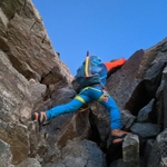
After leaving Gramais, we will go on a rather steep path through pine fields in about 2 hours to the Kogelsee at 2150m. A lake with wonderful reflections. From here then in just under 1 hour up to the Kogelseescharte at 2497m. Now follows the initially quite steep descent down to the Parzinnenseen and then back up to the Gufelseescharte at 2370 m which is reached after about 1 hour. Here we take the final ascent to Kogelseespitze 2647 m.
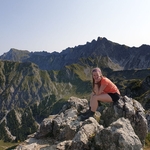
Kogelseespitze is an excellent panoramic mountain with the panorama of the Lechtal main ridge especially the Dremelspitze, looking like a dome, as well as the chain of the Allgäu Alps in the north behind the deeply cut Lechtal, and further Wildspitze, Zuckerhütl, Zugspitze and many others, plus last but not least a wonderful view of the lakes surrounding the peak.
Moreover in this area you have a good chance of spotting ibexes. From the Gufelseescharte you go down to the picturesque Gufelsee and continue on a good path to the junction into the valley towards Branntweinboden. The descent is quite steep and has some sections that are secured by a wire rope. Once at the bottom you can cover the remaining 3km towards Gramais much more easily.
Good to know
Waterproof hiking boots
Cash for the ride
Passport/ID
Food/drinks for the way (we will stop at a gasthaus in Gramais when we are back to the car but we dont have any hut on the way. So make sure you have enough with you)
Comments
Amit Verma
5 years ago
@Sarah, please contact me at hikingbuddiesteam@gmail.com.
1
|
0

Marco Mecarozzi
5 years ago
So. One day to go. Really looking forward tomorrow! Expect Sunny or Little clouds. Temperatures around +14° at 2000m a bit lower on the peak. So bring maybe also and extra layer. Little chances for some showers but they should be in case only in the evening. Dont forget to bring food and water with you. No hut on the way. We Will stop at a gasthaus in Gramais After hike before coming back. Please try to be punctual tomorrow. Looking forward to see you all. 😊
4
|
0
Thomas T.
5 years ago
there's now a free seat in my car again
0
|
0
Iva
5 years ago
We're already here.See you in bit :)
0
|
0