Uploading...
Overall progress...
0%
File progress...
0%
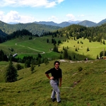
Edit event: Bayrischzell to Brannenburg [15.3 Km, 904 m gain]
T2 - Bayrischzell to Brannenburg [15.3 Km, 904 m gain]
 Organized by:
Route
Bayrischzell to Brannenburg
| Elevation gain |
| Elevation loss |
| Distance |
| Duration |
| Highest altitude |
| Rating |
Gallery
Participants
You need to be logged in to see the participants
Weather
°
°
°
°
Description
The hike takes 7 hours. It is a long hike, so you should have done at least a few hikes this year to be fit for this one.
We go to Bayerischerzell with BOB train and start the hike from there.
Please bring food, enough water (3 liter), hiking shoes, sun cream, an at least 15 euro for train ticket and any emergency.
Please
1. download the route on your phone, download komoot or another GPX viewer app, so you can open the route on it,
2. download the map of the area on your phone with MAPs.ME app.
All of you should have the route and a gpx viewer app on your phones.
Disclaimer: This is not a guided tour. I am not a professional mountain guide.I didn't do this route before. Each participant is responsible for her-/himself and has to be prepared, bring suitable equipment (if s/he thinks it is necessary to bring), bring water and food and has to check if s/he meets the physical requirements. Hiking includes a certain risk and everybody is responsible for his/her own safety. It is highly recommended having some kind of insurance in case of incident.
Comments

Ishan
5 years ago
Hi Pegah, is it possible for you to do this hike on Saturday? If yes, then I would join :)
Regards Ishan
0
|
0

Pegah T
5 years ago
Hi Ishan, it will probably rain on Saturday
1
|
0

Evelīna
5 years ago
Hi Pegah, is there any chance that the number of participants will be increased?:)
0
|
0
Pegah T
5 years ago
List is extenden.
0
|
0
Pegah T
5 years ago
Dear all, due to injury in my leg, the current route can cause me more pain and injury. To not disappoint you and cancel the hike totally, I am going to do the following route tomorrow.
https://www.komoot.com/tour/r269845123?ref=atd
0
|
0

Rudrava Roy
5 years ago
Hi Pegah. Sorry to learn about your injury. Do you still _want_ to go, or would you rather skip the hike? I can take charge in case you want to skip. I've not been active on Hiking Buddies, but I go hiking quite regularly and I've led groups.
0
|
0
Pegah T
5 years ago
Hi, thanks for the offer. We will do an easier hike, you see the link to the route.
0
|
0
Pegah T
5 years ago
Please join the whatsapp group.
https://chat.whatsapp.com/D8mx2rZf0h89yx8fhQEpvw
0
|
0
Ananya Bajpai
5 years ago
Hey guys the original hike is still on. T2 - Bayrischzell to Brannenburg [15.3 Km, 904 m gain]. My friend Rudrava will take over since Pegah got injured. Please join this group https://chat.whatsapp.com/D8mx2rZf0h89yx8fhQEpvw :D
1
|
0
Juan Consiglieri
5 years ago
The event is posted as T2, but in Komoot is classified as difficult /expert hike https://www.komoot.com/tour/46860566 with 1.260 m of descent, is it correct?
0
|
0
Pegah T
5 years ago
I am not sure how komoot rates the hike but the original route is very Streep at some point, you can check it b movinh the Mousse over steepness Profile of the hike. At several point you have Harpune 30% steepness which is not easy to be honest. It is why I earlier today suggested to reolace the original hike with an easier one. However, since now I am out die to injury, I leave it to you which route to take. Both the original route and the route I posted today start in Bayrischzell.
0
|
0
Rudrava Roy
5 years ago
Hi All,
I will be leading the 'original' route tomorrow morning [~15km, ~900m elevation gain]. Please consider these factors:
- There is likely no food or water on the route. So bring both
- This will be 8 hours or more round trip from Hbf. Better not to plan anything for the evening.
- We will go through a pass and then a valley and the weather forecast is cloudy. If there is a breeze, it can get quite chilly. So bring enough layers of warm clothing.
- Worst case train ticket cost is 15.50€. Bring enough cash with you for that and potentially a meal afterwards.
- Be at the platform on time so I can buy the right number of tickets.
See you tomorrow morning 08:45 at Hbf Platform 33. We are taking BOB86809
2
|
0