Uploading...
Overall progress...
0%
File progress...
0%
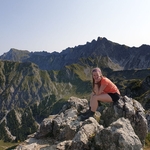
Edit event: Fockenstein via Geierstein from Lenggries [20.1 Km, 1256 m gain]
T3 - Fockenstein via Geierstein from Lenggries [20.1 Km, 1256 m gain]
 Organized by:
Route
Fockenstein via Geierstein from Lenggries
| Elevation gain |
| Elevation loss |
| Distance |
| Duration |
| Highest altitude |
| Rating |
Gallery
Participants
You need to be logged in to see the participants
Weather
°
°
°
°
Description
Sunday looks promising. It will be mostly cloudy with some early snow fall around in the early hours and some rain during the evening. So from 9am till 5pm it should be fine, just slightly coldish and with light winds :)
Since it's a rather long hike - you need to be in good fitness level, surefooted and have head for heights.
This route is not suited for beginners. The pace will be moderate (approx. 400-500hm/gain).
We are looking at about approx. 7 hours in total. Depending on the on-site conditions.
If you haven't been hiking recently and are not really into longer hikes at 5 - 10 °C, this hike might not be what you are looking for. Based on planned hike's pace & group dynamics,I reserve the right to remove you from the attendance list if I think you'd not be able to follow along (based on your profile reviews & prior hikes).
Peaks we will be crossing are Geierstein, Schlagkopf to Fockenstein with nice viewpoints at Neuhütteneck and Hitschsättel.
Departure: We meet 07:40 at Munich Hbf Pl 34 and take the BOB86907 at 08:04 to Lenggries. We arrive at 09:11.This is our starting point. From then on we have about 15min walk to Maximilianweg where we start our ascent to Fockenstein via Geierstein . Descent is over Neuhütteneck and Hirschtalsättel.
Return: We aim to get the 17:17 BOB 86946 to Munich. Alternative trains at 17:47 and 18:17.
If the weather changes and is not so favourable I will cancel the hike.
Note: Please unjoin the event well in advance, if you don't plan to come. You cannot unjoin the event, when it is starting in less than 12 hours.
Disclaimer: Hiking can be dangerous. I am not a mountain guide. Everybody is responsible for her/himself. Make yourself familiar with the route and its requirements. It's recommended to download a map and bring a cell phone and first aid kit for emergencies.
Good to know
Please bring the usual:
- mask
- cash for the ticket
- first aid kit
- id & fully charged smartphone with gpx route saved and 112 number as well
- enough water and snacks to keep you fueled during the hike (min 2L water since it's a long hike)
- gloves to keep your hands warm
- hiking boots (waterproof)
- hiking poles (optional)
- headlamp (just in case)
- rain jacket as the weather can easily change
- dress appropriately for the weather (think in layers - base, mid, soft, hardshell) It will be 5-10 C during the hike.
- extra t-shirt to change into after reaching the peak (recommended)
- sun glasses & sun cream
- cap
- good mood :)
Comments
Iva
5 years ago
Hi together, just an update regarding tomorrow's hike.Temperature will be between 4-7 degrees during the hike with light wind. Up on the peaks around 2-3 degrees but can feel colder.Anticipating light rain around 1pm for duration of 1hour, max 2 hours.Please dress accordingly and be aware that the ground will be slightly moist and some sections muddy as today is light raining in the area and during the night it will also rain. Other than that, have an amazing start in the weekend and see you tomorrow for an autumn hike ;)
0
|
0