Uploading...
Overall progress...
0%
File progress...
0%
Edit event: Schrecksee [18.9 Km, 1543 m gain ca.7:30]
T3 - Schrecksee [18.9 Km, 1543 m gain ca.7:30]
 Organized by:
Route
Schrecksee
| Elevation gain |
| Elevation loss |
| Distance |
| Duration |
| Highest altitude |
| Rating |
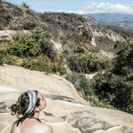
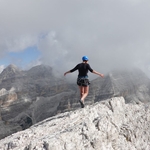
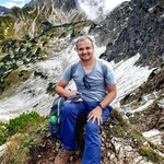
Gallery
Participants
You need to be logged in to see the participants
Weather
°
°
°
°
Description
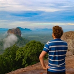
Let's take a hike to Germany's highest alpine lake with an island on 1813 m! Located in the Swabian region of Allgäu, the natural lake lies in the Alps — but getting there is no easy feat. Hiking up to the Schrecksee takes about seven to eight hours round-trip, on average. The views, however, are worth the effort!
Please, pay attention - we are going to follow this route to Schrecksee
https://www.hiking-buddies.com/routes/routes_list/462/
Weather forecast at Schrecksee: https://www.meteoblue.com/de/wetter/woche/47.437N10.466E
As the weathaer forecast can change we may adjust our route as well and go just to the lake and back.
CARPOOL
If you have a car, please add it to the carpool, add the meeting point and time, which is best for you and price for the ride.
Destination: Parkplatz Vilsalpsee
6675 Tannheim, Österreich
https://goo.gl/maps/7zZj5znYcJuGse7c8
WARNING!
I'm quite a slow hiker. If you a fast hiker, this one might be too slow for you.
Looing forward!
Good to know
Things to bring:
- Hiking shoes
- Trekking/hiking poles
- Mask
- Passport/ID
- Food/drinks
Disclaimer: Hiking can be dangerous. I am not a mountain guide. Everybody is responsible for her/himself. Make yourself familiar with the route and its requirements. It's recommended to download a map and bring a cell phone and first aid kit for emergencies.
Comments
Andreas Reingruber
5 years ago
Here I can type more words: I'm driving from my hometown in Northern Bavaria. It's about 135kms more to drive if I'm going over Munich. (that's no problem for me). That is why I suggested 20 € in total. But it's negotiable 😉. Give me a calculation and it's fine.
It would be good if you are all meeting at the same point. 🙃
0
|
0
nuria roig
5 years ago
For me its fine, from where in Northern Bavaria are you coming? will you pass by Freising?
0
|
0
Lisette
5 years ago
Yep, I live in Maxvorstadt so anywhere accessible by tram/u bahn is good. I am going on a sunset hike today so may not be available until +- 21:00
0
|
0
Thomas T.
5 years ago
usually HB share only the expenses for the route travelled together
0
|
0
Andreas Reingruber
5 years ago
Thomas: Yeah. I know what you mean. See it just as an offer : my direct way would be a lot shorter.
It's about 270 km I'll drive more during the day. How would you calculate it?
0
|
0
Thomas T.
5 years ago
The carpool shows 20,0 / person for your car, which is probably not what you meant. however, 20 divided by 3 or 4 should be totally fine.
0
|
0
Andreas Reingruber
5 years ago
@Nuria : Driving down the A9 coming from the area around Ansbach.
0
|
0
Andreas Reingruber
5 years ago
@thomas 20 divided with 3/4 would be perfect for the others 😉. Google says that it's oneway Munich to Schrecksee around 175 km . So 350 in total. Let's say the car needs 8 liters on 100 kms. (120km/h)
3,5 x 8 x 1,25€ = 35 €. /4 = 9€
It's just a rough calculation. I think the car needs more and the 175 kms are starting somewhere right in the middle of Munich.
I need to consider the way I'm driving more towards Munich.
So yeah, maybe it's not 20 but 17 € but as I wrote it's negotiable.
0
|
0
Thomas T.
5 years ago
I see. I suggest meeting at Pasing Bhf (west of Munich). from there is about 160km to Hinterstein. IMHO 13-14€/p would be fair.
0
|
0
Andreas Reingruber
5 years ago
I suggest to start at around 6:20 from Munich as there is less traffic.
1
|
0

Elle Che
5 years ago
Just in case - there is a car, which starts from Kempten at 8:10. So its possile to go by train to Kempten at 06:21/6:53
1
|
0
Dr Vinod K. Pandey
5 years ago
Update: I can passby Kempten at 8 am.
0
|
0
Lisette
5 years ago
Hey all, Elle texted me that she would feel more comfortable if I unjoined because she's afraid I might be too tired (bc I did an after work hike). I'm usually fine with it but wasn't feeling so well tonight so I think it might be a good idea. I can't unjoin Andreas' car anymore but someone could take my spot if they still see this. Sorry for the inconvenience and sad to miss such an amazing hike. Hope you have great day tomorrow!
0
|
0