Uploading...
Overall progress...
0%
File progress...
0%
Edit event: Gschwender Horn [12.5 Km, 761 m gain]
T2 - Gschwender Horn [12.5 Km, 761 m gain]
 Organized by:
Route
Gschwender Horn
| Elevation gain |
| Elevation loss |
| Distance |
| Duration |
| Highest altitude |
| Rating |
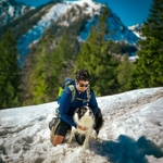
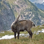
Gallery
Participants
You need to be logged in to see the participants
Weather
°
°
°
°
Description
Technical difficulty: This hike is easy with SAC scale of T1-T2. You just need to enjoy hiking.
What to bring:
- MASK for covering Mouth.
- Personal items (house keys, wallet, ID, some money, phone)
- Optional: Battery pack for the phone
- Water (1.5 L +), food and snacks
- Sunglasses, sunscreen, hat
- Hiking shoes, hiking clothes
- Basic First aid: footcare (if needed).
- Hiking poles/sticks
- Hygiene: Taschentuch, Mouthcare
- Headlamp
NOTE: I am not a professional guide. Each participant is responsible for her-/himself and has to be prepared, bring suitable equipment (if s/he thinks it is necessary to bring) and has to check if she/he meets the physical requirements. Hiking includes a certain risk and everybody is responsible for his/her own safety. It is highly recommended having some kind of insurance in case of incident.
COVID-19 Blurb: DO NOT join if you have any symptoms or feel you may have been in contact with a positive recently. Be responsible. Act respectfully.
Good to know
We drive by car from Munich to Immenstadt im Allgäu (https://goo.gl/maps/5GXYAPBu3eSwCYM5A) and then we start the hike. Wearing a Mask inside the car is mandatory!
Please download the gpx map for offline view : GPXTracker works for iphone, "GPX Viewer from Venture" might be good for android.
Comments
Alpana Chaphalkar
5 years ago
i have added the meeting point based on my convenience, if the journey to the meeting point is longer or with more than 2 changes via public transport then message/mail me in advance. i can pick you up at another meeting point according to your convinience.
1
|
0
Manas Saha
5 years ago
Thanks Alpana . Not sure if we three can travel together in current situation , let me know accordingly then i will unjoin the event.
1
|
0
Alpana Chaphalkar
5 years ago
Ok I will let u know Manas.
0
|
0
Andrea
5 years ago
Only two households can meet/travel/do outdoor sports.
1
|
0
Andrea
5 years ago
@Manas the same applies to your Rotwand hike.
1
|
0
Alpana Chaphalkar
5 years ago
@Manas, unfortunately i have to remove you from the hike. You can also remove me from yours.
0
|
0
Alpana Chaphalkar
5 years ago
@Manas luckily Helga dropped out of this hike. so if u r still interested u can join this hike. And u can remove me from your hike.
1
|
0
Manas Saha
5 years ago
Hey Alpana , I will give you the company in your hike :) . I will come . Please edit the participants count as 2 in your event for tracking.
1
|
0
Alpana Chaphalkar
5 years ago
@Manas, HB website does not allow me to reduce the count, it seems. So i just adjusted the count in carpooling.
1
|
0
Manas Saha
5 years ago
Perfect , Thanks.
Even i have noticed the same in my event as well , seems like an issue with HB website .I will email you my personal number to co-ordinate with you.
1
|
0
Manas Saha
5 years ago
Hey Alpana - Do you mind if you can share your number with me ?
0
|
0
Manas Saha
5 years ago
Hey Alpana - Extremely sorry to say this on a last minute . I will not be able make up , stuck with small knee injury .. even i have to cancel my Rotwand trip as well . Apologies again
1
|
0