Uploading...
Overall progress...
0%
File progress...
0%
Edit event: Kleine Ochsenwand + Gamskogel from Kemater Alm (T4) [16.1 km, 1421 m gain]
T4 - Kleine Ochsenwand + Gamskogel from Kemater Alm (T4) [16.1 km, 1421 m gain]
21Aug
Sat
09:10
Kemateralm Parkplatz (Kemater Alm, 110, 6095 Grinzens, Austria)
 Organized by:
Marco Mecarozzi
Organized by:
Marco Mecarozzi
Route
Kleine Ochsenwand + Gamskogel from Kemater Alm (T4)
| Elevation gain |
| Elevation loss |
| Distance |
| Duration |
| Highest altitude |
| Rating |
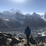
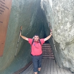
Gallery
Participants
You need to be logged in to see the participants
Weather
°
°
°
°
Description
This Is a carpool hike. Please read carefully instructions for the hike and don´t just click on coming.
CARPOOL
Schedule: Hike starts at 8,50 am.
Drivers: add your car in carpool and put meeting point and time for it.
Passengers: Click on Carpool button. Read carefully all information about the car you join, check if there are any specific instructions. All the costs for the trip will be shared with people in the same car. Meeting point is decided by the driver, this information is in the "Carpool" button.
Please be punctual.
The hike is in Austria, that means All travellers need to show either a negative COVID test or proof of vaccination/past infection upon entry.
Instructions for the hike
The hike is not for beginners. It requires a proper level of fitness given the distance and the altitude gain. Travelling costs will be shared in each car.
Hiking can be a dangerous activity. Everyone is responsible for him/herself. I am not a professional guide.
Hike Description
Hidden deep in the Senderstal valley in Stubai Alps, are the Kalkkögel - a group of rugged gray-blue limestone giants in the middle of rubble giants, deep crevices in the rock, mountain pine topping. The North Tyrol Dolomites. Impressive!
The Kleine Ochsenwand is a mountain located between two big peaks Große Ochsenwand and Steingrubenkogel. The summit can be reached in a few minutes from the Alpenklub-Scharte - the transition from the Senderstal to the Schlick. The views down into the Schlick and the Adolf-Pichler-Hütte are particularly beautiful.
From the parking lot below the Kemater Alm, turn left past the Alm and follow the signs to Adolf-Pichler-Hütte, up the wide gravel path. First you hike exactly towards the mighty rock towers of the Kalkkögel. After a few minutes' walk you cross the Griesbach and finally climb in several bends up to the Adolf-Pichler-Hütte (1977m), which is beautifully situated on an edge of the terrain with a fantastic view. From the hut, follow the signs to the Alpenklubscharte / Steingrubenkogel and hike with a little gain in altitude in a south-easterly direction through grassy terrain, past a monument to the left, towards the clearly recognizable Alpenklub-Scharte between the Steingrubenkogel and the Kleine Ochsenwand. After a short time you reach the steep, wide cirque that stretches down from the saddle to the valley floor. Through this one climbs steeply on the serpentine path up to the Alpenklub-Scharte (2451m), where a magnificent view opens up to the east down into the Schlick. From the saddle, follow the signs to the Kleine Ochsenwand to the right, after a few meters leave the trail that continues to the foot of the Große Ochsenwand and at the beginning, with the help of your hands, climb up a short, steep step to the right on the grassy south-east flank. Over this, following the climbing tracks up to the small summit cross on the Kleine Ochsenwand (2553m). After enjoying the magnificent all-round view and the beautiful deep view of the Adolf-Pichler-Hütte and the Kemater Alm, you have to go back to the Alpenklub-Scharte. From there From the Seejöchl we have a really great view. Right next to us is the foot of the 2804 meter high Schlicker Seespitze, the highest mountain in the Kalkkögel. A few meters below us lies the Schlicker See, actually two small lakes. To the left we see the Stubai trail which leads to the Starkenburger Hut. Like our ascent route, it leads through scree along the mountain slope. The view leads to the mountain opposite, the Hohen Burgstall, a mighty rock mountain, but at 2611 meters its summit is only slightly higher than our location here on the Seejöchl. Further back we can see the Stubai Alps with the Habicht and the main Alpine ridge, if they are not covered by the clouds that are coming in from the Stubai Valley. On the right we can follow the course of the Stubai High Trail a few meters further, which in this direction will still take a few hours distant Franz-Senn-Hut. Our further path runs over it, which should lead us to the summit of the Gamskogel in half an hour. On the right we can follow the course of the Stubai High Trail a few meters further, which leads in this direction to the Franz-Senn-Hut, which is a few hours away.
We finally come back to Kemater Alm for a well deserved meal crossing the beautiful Senderstal Valley.
Good to know
Waterproof hiking boots
Rain jacket
Cash for the auto
Food/drinks for the way (we will stop at Kemater Alm before leaving, but otherwise we don't have any other hut on the way, so consider to Carry 2-3 liters with you).
Good Mood
Get familiar with the route before we go
Comments
Junghan
4 years ago
Marco, hike starts at 09:10 or 08:50?
0
|
0

Marco Mecarozzi
4 years ago
I have written 9,10 since Google was saying to me about 2 h till there. So leaving Munich at 7 would make sense. :)
0
|
0
Junghan
4 years ago
Those needing a ride AND more than certain will make it, do write your mobile phone number.
Descriptions on the carpool list.
Might take sometime to reply as I will be out tonight but latest tomorrow before noon.
0
|
0
Junghan
4 years ago
car is full
0
|
0
Raul Fabregat
4 years ago
Marco, Hike starts at 9.20
0
|
0
Yuliya Da
4 years ago
https://chat.whatsapp.com/EyTybyW52O68pI65zLG4uH
2
|
0
Raul Fabregat
4 years ago
I put all fotos in HB. there is nothing to hide.
0
|
0
Yuliya Da
4 years ago
Still, please join the group for the other pictures ;)
0
|
0
Raul Fabregat
4 years ago
Ill try. Im not fit with new technologies.
0
|
0
Raul Fabregat
4 years ago
Fotos without Filters ;) . Next time try to select the better. Very good ( und piu bella) Hike. Marco always best Choice.
2
|
0