Uploading...
Overall progress...
0%
File progress...
0%
Edit event: Schafberg and Spinnerin
T3 - Schafberg and Spinnerin
 Organized by:
Route
Schafberg and Spinnerin
| Elevation gain |
| Elevation loss |
| Distance |
| Duration |
| Highest altitude |
| Rating |
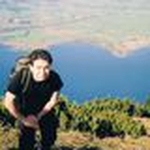
Gallery
Participants
You need to be logged in to see the participants
Weather
°
°
°
°
Description
This Is a carpool hike. Please read carefully instructions for the hike and don´t just click on coming.
CARPOOL
Schedule: Hike starts at 9,15 am.
Drivers: add your car in carpool and put meeting point and time for it.
Passengers: Click on Carpool button. Read carefully all information about the car you join, check if there are any specific instructions. All the costs for the trip will be shared with people in the same car. Meeting point is decided by the driver, this information is in the "Carpool" button.
Please be punctual.
The hike is in Austria, that means All travellers need to show either a negative COVID test or proof of vaccination/past infection upon entry.
Instructions for the hike
Pace won´t be fast. The aim of the hike is to enjoy the beautiful views that this peak has to offer. The hike is not for beginners. It requires a proper level of fitness given the distance and the altitude gain. Travelling costs will be shared in each car.
Hiking can be a dangerous activity. Everyone is responsible for him/herself. I am not a professional guide.
Hike Description
The "Wolfgangseer Schafberg" is one of the peaks with most beautiful views in Austria. Wherever you look, your eyes will be hit by the blue of alpine lakes on all sides. This mountain located in Salzburgerland is surrounded by three of the main lakes of the Salzkammergut: Wolfgangsee, Mondsee and Attersee plus Irrsee and Fuschlsee and in clear days even Chiemsee in Bayern. Plus the view from the summit (1783m) guarantees the gorgeous mountain scenery of Höllengebirge range, Dachstein Mountains and famous Watzmann.
This hike starts at Kreuzstein at Mondsee, impresses with many highlights, such as the Kreuzstein waterfall, idyllic Streams, impressive bridges and picturesque alpine meadows till the final views from the peak.
We park at the parking lot of the public bathing area. In the water we see a stone with two crosses, after which the area is named "Kreuzstein". From there it goes steeply into the forest, where the first highlight after 10 minutes is the Kreuzstein waterfall. Continuing further through the forest up over several streams and a spectacular bridge construction with well-insured ladders we come to a hunting lodge with an ingenious view over the Mondsee. From here it is only a few minutes until we arrive at the Eisenauer Alm.
On the Eisenau, turn right across alpine meadows back into the forest. There follows a steep ascent to the Suissensee. Once at the top, turn right, always along under the Schafberg summit. The last piece is the so-called Himmelspforte - this is where it gets a bit tricky. The steep and rocky path places high demands on the hiker and should only be walked on when it is dry. The Schafberg is waiting with a great view.
Shortly afterwards, the sparsely marked, narrow mountain path to the Spinnerin branches off to the left without any signposts. The grassy, rugged southern flank becomes noticeably steeper. We reach the saddle between Schafberg and the now imposing cliff of the Spinnerin. A little below the edge of the ridge, the narrow climb winds past the white statue of the Virgin in the now quite steep southern flank, surprisingly easy up to the unadorned highest point of Spinnerin.
We come back the same way of the ascent.
Good to know
Waterproof hiking boots
Rain jacket
Cash for the auto
Food/drinks for the way (we will stop at the hutte before leaving, but otherwise we don't have any other hut on the way, so consider to Carry 2-3 liters with you).
Good Mood
Get familiar with the route before we go
Comments
Nuno Madeira
4 years ago
Hello, would it be okay to join from the point of departure in Kreuzstein? I'm based in Salzburg which is not far with public transport. Thanks!
0
|
0
Nuno Madeira
4 years ago
The last bus to Salzburg via Mondsee is at 5.26pm. I guess the hike ends around 4pm, right?
0
|
0

Marco Mecarozzi
4 years ago
Yes you can join us from there. About the end of the hike, being a group hike I cannot ensure that. Honestly i am not sure that time we Will be down. Most probably not since We want Also to spend quite some time on the peak and drink something at the hut.
0
|
0
Nuno Madeira
4 years ago
Thanks for the info. I'll see if I can find a solution for the way back
0
|
0
Nuno Madeira
4 years ago
Hello again, just to let you know that I've found a solution for the way back. See you on Saturday!
1
|
0
Marco Mecarozzi
4 years ago
See you!
0
|
0
Reza Mortazavi
4 years ago
Hello, is the valley station of the Schafbergbahn near the starting point?
0
|
0
Marco Mecarozzi
4 years ago
https://maps.app.goo.gl/chSaEZvEuXeBMyocA
0
|
0