Uploading...
Overall progress...
0%
File progress...
0%
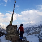
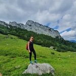
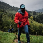
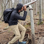
Edit event: Immenstädter Horn and Gschwender Horn [Sponsored by Arc'teryx]
T2 - Immenstädter Horn and Gschwender Horn [Sponsored by Arc'teryx]
 Organized by:
Route
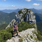
Immenstädter Horn and Gschwender Horn
| Elevation gain |
| Elevation loss |
| Distance |
| Duration |
| Highest altitude |
| Rating |
Gallery
Participants
You need to be logged in to see the participants
Weather
°
°
°
°
Description
UPDATE: Due to current weather forecast the hike has been moved to Sunday.
Arc'teryx sponsored hike: This hike is sponsored by Arc'teryx.
- Arc'teryx will cover the transportation cost for everyone.
- Each participant will receive Goodies (i.e., toques, beanies, t-shirts etc.)
- Each participant can get a test gear (gloves, jackets, backpack) for 1 month. Please use the following list to select the test gear: test gear. You can contact me directly with your choice.
- Route maybe modified based on the conditions of the day of the hike.
You can choose the item you want to have from the following table :
Item number | Item | Color | Size | Available Numbers |
| 25633 | Bird Cap | Black | NA | 3 |
| 25633 | Bird Cap | Conifer | NA | 3 |
| 28599 | Small Bird Hat | Fluidity | NA | 3 |
| 28599 | Small Bird Hat | Jupiter | NA | 3 |
| 29866 | Taema Arc'Word SS Women's | Vitality Heather | S | 4 |
| 26841 | Cormac Crew SS Men's | Microchip | S | 1 |
| 26841 | Cormac Crew SS Men's | Ignite | M | 2 |
| 29862 | Arc'Logo Emblem SS T-shirt Women's | Mesmer | XS | 2 |
Participation criteria:
- You have no "no-shows" in last 6 months and you have done at least 5 hikes in Hiking Buddies,
- You have no objections in being photographed those pictures will be used in social media.
- You have not joined any of the previous Arc'teryx sponsored hikes.
Technical difficulty: The hike has difficulty T2, please read the blog to understand the requirements for sac scale T2. Please note that depending on the conditions, I might change the route.
Things to bring:
- Waterproof hiking boots
- Covid certificate and mask (for the hut)
- Food/drinks
- Warm clothes
To do before the hike
Download the gpx file and offline map of the area in your phone/navigation device with the knowledge of how to use it. You can look at this post for the most popular navigation apps.
https://www.facebook.com/groups/hikingbuddiesmunich/permalink/4792626297522667/?app=fbl
Known bug: check the file you have downloaded has a .gpx extension. If not, just rename it, as it might happen that you get a ".gpx.xml" file instead of just ".gpx", especially when downloading from a phone.
Note: Please unjoin the event well in advance, if you don't plan to come. You cannot unjoin the event, when it is starting in less than 12 hours.
Disclaimer: Hiking can be dangerous. I am not a mountain guide. Everybody is responsible for her/himself. Make yourself familiar with the route and its requirements. It's recommended to download a map and bring a cell phone and first aid kit for emergencies.
Comments
Danial Tayari
3 years ago
Description has been updated. Read it again and send me a message with the gear you want to test and the item you want to receive.
1
|
0
Danial Tayari
3 years ago
Another reminder to sent me a message with your item of choice and if you wish a gear to test.
0
|
0
Danial Tayari
3 years ago
So far only two people have contacted me and I have to remove the people from the hike if I don't get any answer. In case you are not sure to attend the hike, you can still choose a gear and it will be given to other participants if you drop out.
0
|
0

Patrick W
3 years ago
Hi Danial, the description says everyone can test, and you said in your previous comment "if we wish" now it sounds like mandatory? For me there is nothing interessting to test in the list currently, as most items seem already lended out
0
|
0
Danial Tayari
3 years ago
there is one item that you can have for yourself from the table. for that I need your input. for testing a gear( not mandatory) there is a link in the description that you can choose the gear from.
0
|
0
Danial Tayari
3 years ago
if you do not wish to have an item for yourself it is also fine just let me know.
0
|
0
Danial Tayari
3 years ago
Everyone who is joining the hike needs to come at the meeting point by 7.
0
|
0
Eugénie Bastié
3 years ago
hi Danial! would like to join this event
0
|
0
Danial Tayari
3 years ago
you can join if you make it to main list.
0
|
0
Danial Tayari
3 years ago
Hike has been moved to Sunday.
0
|
0

Soumya D
3 years ago
I would be up if there's any upcoming spots available 🤞
0
|
0

Reza Mortazavi
3 years ago
Hello Danial, I already have everything I need. So I don't have to test anything.
0
|
0
Goutam Tanti
3 years ago
oh no.. I can't make it on this Sunday 😢
0
|
0
Danial Tayari
3 years ago
Take your rain jacket and spikes with you
1
|
0
Anmol Prakash
3 years ago
Is it ok if I catch the train at Pasing?
0
|
0
Danial Tayari
3 years ago
no, to be considered in the ticket you need to be at hauptbahnhof.
1
|
0
Anmol Prakash
3 years ago
I missed my connecting train and wont make it 😪
0
|
0
Emma-Lee Knape
3 years ago
Add your photo shoot shots here: https://photos.app.goo.gl/o9zUtTkyZkPA1FVw5
1
|
0