Uploading...
Overall progress...
0%
File progress...
0%
Edit event: Teufelstättkopf & Pürschling
T2 - Teufelstättkopf & Pürschling
14May
Sat
09:00
Parken Pürschling https://goo.gl/maps/sdNp5GBPx2nitnkHA
 Organized by:
Alpana Chaphalkar
Organized by:
Alpana Chaphalkar
Route
Teufelstättkopf & Pürschling
| Elevation gain |
| Elevation loss |
| Distance |
| Duration |
| Highest altitude |
| Rating |
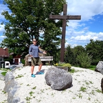
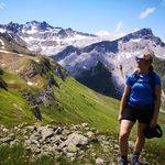
Gallery
Participants
You need to be logged in to see the participants
Weather
°
°
°
°
Description
THIS HIKE CAN BE POSTPONED IN CASE OF BAD WEATHER & CORONA SITUATION!
I am currently keeping the participant count to 4, if need arises i will increase it later.
Teufelstättkopf is one of the most popular mountains in Ammergauer alps. This hike is mostly T2 except the last couple of meters to the peak.
The route can also be tried in winter given that: 1) Avalanche risk is under limits, and 2) you have proper equipments to traverse icy ridge (crampons, groedels etc.)
Ascent: The start point of the hike is Unterammergau. Follow the directions towards Schleifmühlklamm. The walk through the gorge is just stunning. There is no entry fee to the gorge. After the gorge follow the directions to Kuhalm, from there the path becomes steep and narrow before going to the ridge. In the ridge you have amazing views of Karwendel, Wetterstein mountains and Allgäu and Ammergauer alps. You need good orientation skills and sure footedness in the ridge. The last few meters to the peak has a section with rope. In winter the ropes are covered by snow, so one needs to be careful in this section.
Descent: The descent is from the peak towards Purschling. The most of the descent is along an easy mountain road and poses no difficulties.
Variants:
1) Alpine coaster during descent (only possible in summer) Its possible during May.
Good to know
Carry following things:
- FFP2 Mask
- Vaccination Certificate
- Hiking Boots
- 1-1.5 L water
- Snacks, food (in case we do not stop at the Hut)
- Warm Clother
- Walltet/Money, Keys
- Hiking Poles
Disclaimer: Hiking can be dangerous. I am not a mountain guide. Everybody is responsible for themselves. Please make yourself familiar with the route and its requirements. Additionally, you could download the map, bring a cell phone and a first aid kit.
Comments

Lakshaya Sood
3 years ago
DONT go - route warning - https://www.sueddeutsche.de/bayern/unterammergau-sonnenberggrat-wanderer-unglueck-1.5557376
there were 2 dead bodies in the valley while we were making this hike last sunday
Wait for summers.
I think we were lucky that day and decide to go down when we got a chance.
there are few places to go down the ridge otherwise you have to continue on that scary ridge
refer the comments in my event - https://www.hiking-buddies.com/routes/events/4880/
I think there is the reason why it is called "Am Zahn" (the teeth of the devil)
2
|
0
Lakshaya Sood
3 years ago
apologies for the false alert. just saw you are not going on the Sonnenberg - Rappenkopf ridge.
anyways be careful!. Best of luck.
0
|
0
Alpana Chaphalkar
3 years ago
Thanks a lot for informing though :)
1
|
0

Dr Vinod K. Pandey
3 years ago
Hello Alpana, I will like to join this. I will come by my own car (live far from Munich) and plan to meet directly at Unterammergau. Hope you increase the no. of participants. Thanks!
0
|
0
Alpana Chaphalkar
3 years ago
Hi Vinod, i have increased the participant count to 8. You can add your car.
0
|
0
Dr Vinod K. Pandey
3 years ago
Thanks Alpana. I got another plan finalized. See you in some other hike.
0
|
0
Alpana Chaphalkar
3 years ago
In case we want to take the Alpine Coaster which is in Oberammergau which is not the starting point. Then we should take different: https://www.komoot.com/smarttour/1978018. Let me know if anyone is interested in Alpine Coaster.
0
|
0
Alpana Chaphalkar
3 years ago
in case of rainy weather i will pospone this hike to 13.05.2022
0
|
0

Rafael Ramalho Figueiredo
3 years ago
Are you expecting the use of equipment for snow hikings? I don't have any...
0
|
0
Alpana Chaphalkar
3 years ago
https://www.facebook.com/media/set/?set=oa.714807329699211&type=3 If you look at this album/post, there was considerate amount of snow on 10.04, and based on https://www.bergfex.com/sommer/ammergauer-alpen/webcams/c4991/, i see some snow at the top. So i would recommend to carry a winter gear. You can ask in FB group https://www.facebook.com/groups/hikingbuddiesmunich if anyone can lend you winter gear for 1 day. I might postpone this hiking event as i see rainy weather on Saturday. I will check the weather forcast on Thursday again and if needed, then i will update this event.
1
|
0
Rafael Ramalho Figueiredo
3 years ago
And would you recomend this hiking for a person that never been in one with snow? I'm quite experienced in hiking/trekking, but i've never been in one with snowy conditions.
0
|
0
Alpana Chaphalkar
3 years ago
Ok. But please do wear hiking boots. I hope there is very little snow.
1
|
0
Alpana Chaphalkar
3 years ago
I am sorry but i have to postpone this hike to next weekend as the weather is rainy and i think the path would be muddy & slippery which would make it difficult to do the ridge part.
0
|
0
Alpana Chaphalkar
3 years ago
This is where i checked the forecast: https://www.bergfex.com/sommer/unterammergau/wetter/prognose/#day2 https://www.accuweather.com/en/de/unterammergau/82497/daily-weather-forecast/177680?day=3
0
|
0
Matthias Schmidt
3 years ago
Do you go or do you will postpone it?
Would come by car separately if its possible to join. Cheers Matthias
0
|
0
Alpana Chaphalkar
3 years ago
It seems the weather on Saturday is rainy. So if the weather is rainy i will probably postpone again.
2
|
0
Alpana Chaphalkar
3 years ago
I saw the weather forecast and It seems there's a light Rain. I will Check It tomorrow in the afternoon again and confirm.
0
|
0
Alpana Chaphalkar
3 years ago
i checked the forecast today and it seems there is a possibility of light rain: https://www.bergfex.com/sommer/unterammergau/wetter/prognose/#day1 & https://www.meteoblue.com/en/weather/week/unterammergau_germany_2820020?day=2 Please join the whatsapp group: https://chat.whatsapp.com/L0o91bTt0c3CrAtoZuUJou.
0
|
0
Dominique L
3 years ago
hi Alpana, when is the meeting time tomorrow at the Parkplatz? is it 7:30am or are you leaving from munich at 7:30am?
0
|
0
Alpana Chaphalkar
3 years ago
Hi Dominique, it is at 7:30 am from Munich. We will start hiking by 9 am.
0
|
0
Matthias Schmidt
3 years ago
I will meet you guys at the Parkplatz too
1
|
0
Alpana Chaphalkar
3 years ago
@Matthias, can you please join the whatsapp group: https://chat.whatsapp.com/L0o91bTt0c3CrAtoZuUJou this would be better for communication
0
|
0