Uploading...
Overall progress...
0%
File progress...
0%
Edit event: ⚡⚡ Krapfenkarspitze - Soiernsee - Soiernspitze(2253m) - Schöttelkarspitze - Seinskopf
T5 - ⚡⚡ Krapfenkarspitze - Soiernsee - Soiernspitze(2253m) - Schöttelkarspitze - Seinskopf
 Organized by:
Route
Krapfenkarspitze - Soiernsee - Soiernspitze - Schöttelkarspitze - Seinskopf
| Elevation gain |
| Elevation loss |
| Distance |
| Duration |
| Highest altitude |
| Rating |
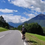
Gallery
Participants
You need to be logged in to see the participants
Weather
°
°
°
°
Description
Please read the description in web version
required pace - 500m/h [ascend] & 700m/h[descend]
Meeting time: Saturday 16th July, 05:45; HBf Platform 34
Please buy your 9 Euro ticket. We will catch the train towards Lenggries - Oswaldhütte, Lenggries at 6:04
We catch the return bus from Isarhorn, Mittenwald - Klais Bahnhof, Krün - Munich.
Last bus connection are at 19:23, 20:06, 21:33, 21:46
route length can be increased by 3km if we have time and energy :)
Things to bring:
- Cash/Paypal for the ticket
- Waterproof hiking boot
- spare socks
- Passport/Id
- Food/drinks for the way
- Raincoat/winter clothes
- set up .gpx route in gpx viewing app (like openstreetmaps, komoot, GPX viewer etc.)
- See corona regulations
Peaks covered
- Galgenstangenkopf (1807m)
- Fermerskopf (1851m)
- Bayerkarspitze (1908m)
- Dreierspitz (1962m)
- Krapfenkarspitze (2110m)
- Gumpenkarspitze (2010m)
- Soiernseen (lake)
- Soiernspitze (2253m)
- Reißende Lahnspitz (2209m)
- Soiernschnied (2174m)
- Feldernkopf (2071m)
- Schöttelkarspitze (2050m)
- Feldernkreuz (2048m)
- Seinskopf (1961m)
- Signalkopf (1895m)
- Lausberg (1854m)
route video - https://www.youtube.com/watch?v=84nbecE0fHs
The path from start to Gumpenkarspitze is documented here https://www.hoehenrausch.de/berge/krapfenkarspitze-bayerkarspitze/
The path from Soiernspitze to end is documented here https://www.bergtour-online.de/bergtouren/bergwanderungen/schwer/soiernspitze/
Good to know
Note: Please unjoin the event well in advance, if you don't plan to come. You cannot unjoin the event when it is starting in less than 12 hours.
Disclaimer: Hiking can be dangerous. I am not a mountain guide. Everybody is responsible for her/himself. Make yourself familiar with the route and its requirements. It's recommended to download a map and bring a cell phone and first aid kit for emergencies.
Comments
Paul E
3 years ago
Anyone there already?
0
|
0
D. B.
3 years ago
yes, stand in front of the metal barrier at platform 34
1
|
0

Lakshaya Sood
3 years ago
i will reach at 6:00. Missed a connection. will be there soon
1
|
0

Amit Kumar Mallik
3 years ago
Please join this group so that we can share photos.
https://chat.whatsapp.com/EK3O5I4yNQaHDEyrhvWUbZ
0
|
0