Uploading...
Overall progress...
0%
File progress...
0%
Edit event: [SWITZERLAND] Sihl - Albispass - Hochwacht Albis - Sihlwald (near Zurich)
T2 - [SWITZERLAND] Sihl - Albispass - Hochwacht Albis - Sihlwald (near Zurich)
 Organized by:
Route
Albispass & Hochwacht from Sihlriver (incl Tierpark)
| Elevation gain |
| Elevation loss |
| Distance |
| Duration |
| Highest altitude |
| Rating |
Participants
You need to be logged in to see the participants
Weather
°
°
°
°
Description
Hike is CANCELED
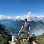
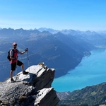
This hike close to Zurich goes up the Albis (same "Albisketten" to which Uetliberg belongs, this peak is a few kilometers to the south of Uetliberg and much less visited). Peak is 903 meters. We also visit a Watchtower (Albis Hochwacht). We use a little known trail. We start at the Wildpark-Höfli Trainstation (near the Sihl) at 460meters, go trough the Tierpark Langenberg (Animal Park) (free entry), cross the main road and start going up the Albis. We take a small side single trail hiking trail which is little known. After 10 minutes we reach a larger hiking path that leads us all the way up the Albis. There is a stop along the way with fresh water. We then continue on the Albis, take a small side track downhill leading to the Albishaus with nice views in the direction of Zug (lake, hills, ...). We then go uphill again to the Hochwacht Albis (watchtower). Views 360 over Zurich, Lake Zurich, Zug, ... etc.
(more details in the route link).
The trail is generally "easy" and has no special dangerous sections, however since we go up/downhill after some rainy days there may be slipper rocks/leaves etc. Proper shoes are required, trekking poles are optional.
* Starting point: Wildpark-Höfli Trainstation
It's a small train station, just wait on the platform after exiting the train. We leave 9.20 SHARP.
If you take the 8.58 S4 train from Zurich HB, you arrive exactly on time (9.17 arrival).
There is also a bike rack. No car parking spaces ! (if you come by car, park else for example Adliswil trainstation and take train for the last part).
* Start time is 9.20 SHARP. There will be NO WAITING FOR ANY LATECOMERS
* Ending point: Bus stop "Unterrengg" (in Langnau am Albis). From there you can take a bus downhill to the trainstation Langnau Gattikon where you can take the S4 train to Zurich every 20 minutes. Note that the hike is not a full loop back to the starting point (since i end the hike nearby to where i live). You can connect with public transport
* Lunch: Picnic: bring your own food !!!
Estimate to eat 30min picnic around 12.00, but this can vary depending on situation. After that it will be mainly downhill.
* Duration: I estimate 4 to 4.30 hours depending on the speed and length of lunch break.
* Bring sufficient water, layers (it might be cold, especially on the top of the Albis it can be a lot more windy & colder)
* WhatsApp Group: I will create an OPTIONAL Whatsapp group for;
1. questions on carpooling/transport if anybody has any, or hike related info
2. Sharing pictures after the hike
3. Sharing live location
You don't have to join the whatsapp group, purely optional. Just click the Join Event button if you want to join the hike and show up on time. Once you Joined this event, I will send the link using Private Message.
* We will walk trough the Animal park, you may be able to see some animals and take some quick pictures, however its not the intention to spend a long time there, we will just walk trough.
* I am not an official guide, babysitter, ... when you join you are fully responsible for yourself. Only join if your health condition allows you to do so. Will not be responsible for any problems or issues. You can turn back anytime you want.
**** THE HIKE MAY BE CANCELLED IN CASE OF BAD WEATHER/RAIN ***
Currently it looks like there will be light rain Saturday night/morning but it should be finished by 09.30. In case the forecast shows rain during the hike, the event will be cancelled/moved to Sunday. Currently it looks like the weather will be ok
Comments

Lionel Guerraz
3 years ago
Charlie,
do you know if there is a car park near Wildpark-Höfli Train station?
0
|
0
Karel Charlie De Gend
3 years ago
If you click on the route, you get more details. There is no car park at that train station no. Best option is to either park in Langnau Gattikon train station or Adliswil train station. Langnau Gattikon station is probably your best choice, as the bus we take at the end goes back to that station as well.
0
|
0
Karel Charlie De Gend
3 years ago
Alternatively, if you are lucky, you may find a spot on the roads nearby. but notice parking spaces are limited and also parking time may be limited
0
|
0
Karel Charlie De Gend
3 years ago
Hi All,
(1) Currently the weather forecast shows rain in the early morning, small chance of rain around 9ish, but should be dry from 10 onwards for sure. Probably we will not have any rain. >>> So the hike is a GO
(2) I have send a message with a link to the WhatsApp group to everybody that joined so far, if you didn't receive it yet please send me private message
1
|
0
Botond Kovács-Nüszl
3 years ago
Hi, I can't find your message with the WhatsApp link. Send it again pls
0
|
0
Karel Charlie De Gend
3 years ago
——- the hike is canceled due to bad weather——— (will rain entire morning)
2
|
0
Lionel Guerraz
3 years ago
thanks Charlie for letting us know - shame about the weather
0
|
0
Karel Charlie De Gend
3 years ago
- CANCELED -
1
|
0
Botond Kovács-Nüszl
3 years ago
I went for this hike today afternoon, there was neither rain nor crowd. Nice route, I can recommend it and the Wildpark too
1
|
0
Karel Charlie De Gend
3 years ago
Great to hear your feedback and that you enjoyed this route !
0
|
0