Uploading...
Overall progress...
0%
File progress...
0%
Edit event: Medium. Vils Vilser Kegel Alatsee Füssen. Panoramic peak, mistery lakes and Christmas markets.
T3 - Medium. Vils Vilser Kegel Alatsee Füssen. Panoramic peak, mistery lakes and Christmas markets.
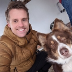
 Organized by:
Route
Vils Vilser Kegel Alatsee Füssen. Panoramic peak, mistery lakes and Christmas markets.
| Elevation gain |
| Elevation loss |
| Distance |
| Duration |
| Highest altitude |
| Rating |
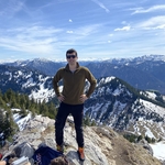
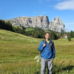
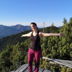
Gallery
Participants
You need to be logged in to see the participants
Weather
°
°
°
°
Description
Let´s go this Saturday for a beautiful long medium winter hike including a panoramic peak with views to 4 lakes and to East Allgäu mountains, few pretty lakes surrounded from legends, Lech waterfalls and Füssen Christmas markets!
The hike is medium. The T5 rating from the system is not appropriate.
What do you need to take part to this hike.
1) Enough fitness for such a long hike
2) Cash for the train ticket (Bayern ticket) and in case for buying food and Glühwein at Christmas markets (many places do not accept cash, so please bring it with you)
3) Team spirit. We are a group, we must act as a group and especially in winter conditions leaving someone very far behind is never a good idea. So put always an eye to the group and no gaps in the group.
4) Motivation to join the event. Motivation is the most important thing in life and hikes, especially in winter requires motivation. At latest please unjoin at 12 pm the day before the hike (About 18 hours before the event) unless you are not feeling good or serious issue comes. Unjoin in the evening makes it impossible to any other buddie would have wanted to join since it would be too late and creates chaos in the waiting list and in the event. Thanks for understanding
5) Please be punctual or you will buy your own ticket if you get to the station after 6,20.
This less frequented tour seems to be a real insider tip for those looking for peace. The tour begins in Vils. Clockwise it goes around the beautiful panoramic mountain. Once left Vils Bahnhof we head towards the Konradshütte near Vils. First it goes on a paved, then gravel road past the hut and with a moderate incline upwards. When entering the forest, the path leads over the ski slope, along the small lift up and after a few minutes on foot meets the wide forest path again. After a few hundred meters the road ends at a stream bed. On the opposite side begins a beautiful, sometimes steep ascent through a coniferous forest. You quickly gain height in small serpentines, on forest floor, over roots and stones. The forest almost has something fairytale-like about it and shows itself from a different side after each crest. Shortly after a small hut, the path is a bit flatter for a moment and the mighty walls of the Karret and the Große Schlicke build up on the left-hand side. There is a short, crisp climb to the first of two larger steps below the so-called Hundsarschjoch. This is followed by a section of the path across gentle meadows. With the yoke in sight and the rugged rock faces and the summit of the Vilser Kegel always in view, you will reach the first stage destination. The Hundsarschjoch is reached at an altitude of 1647m. Where the name comes from? I am not sure ahaha The way to the summit now leads up in about half an hour on a path overgrown with mountain pines. Sometimes there are steep, high steps in the way, sometimes the mountain path is almost reminiscent of a mountain trail. The summit cross is getting closer and closer. Once at the top, the fantastic view of the Ostallgäu opens up. Hopfensee, Forggensee, Füssen and the royal castles of Neuschwanstein and Hohenschwangau. In the back the Great Schlicke, Tegelberg and Füssener Jöchle. We enjoy this beautiful view. AFter that we start the descent to Hundsarschjoch that follows the same route. From there it goes down to the right. Mountain pines, a rock needle and the imposing western walls of the cone characterize the landscape. After many small hairpin bends you finally reach the bottom of the valley and the Vilser Alpe (we could think depending on our timing to have a short break here). Then we follow the road over the Alpstrudel waterfall into the valley.
Here starts the second part of the hike, much more relaxing but also very pretty and interesting. First we cross the borders and we hike back to Germany till we reach Alatsee lake. Alatsee, 35 m deep, is often called “Bleeding Lake” because of the bright pink colored layer of purple sulfur bacteria at a depth of about 15 meters. On a few days of the year, even the surface of the lake shimmers in a reddish hue. No wonder, then, that numerous legends and myths exist around the Alatsee. It is sometimes said that the Alatsee is actually much deeper than expected and that monsters live in these shallows. But it is also said that 3 enchanted women live in the water and try to lure attractive men down to them in order to be redeemed. Even today, it is said on some nights voices are heard calling for help.
On the other side, it is not a rumor that the Nazis used the lake for secret underwater experiments during World War II. Luftwaffe technicians carried out underwater tests with models of the Focke-Wulf Ta 154. For this reason, heavy iron bars and frames can still be found in the lake today. On the other hand, it is disputed whether at the end of the war the Alatsee served as a hiding place for the gold treasure of the German Reichsbank, which was brought to safety from Neuschwanstein one night. Some people are said to still be looking for that treasure.
The water of the lake flows via the Faulenbach valley through Obersee and Mittersee in the Faulenbach valley into the Lech.
After passing these last two small lakes we reach Lechfall, a natural monument that is unique in Bavarian Alps.The water masses of the Lech plunge impressively over five steps 12 meters into the depth. Below the waterfall, the river narrows and enters the Lech gorge! It is time finally to cross the bridge and reach our final destination: Füssen Christmas markets! A long beautiful day with many different and interesting landsscapes must be celebrated with a glühwein together at the markets.
Disclaimer: hiking can be dangerous. I am not a mountain guide. Everybody is responsible for her/himself. Make yourself familiar with the route and its requirements. Here is my phone number to contact me during that day: 017643285424
Good to know
Hiking shoes
Water
Food
Flashlight
Snowspikes
Gaiters
Cash for the train ticket and for food and drinks (many places do not accept cash)
Comments
Julien Allard
3 years ago
"Motivation is the most important thing in life". I wasn't expecting a Hiking Buddies event's description to ever be that philosophical!
1
|
0
Julien Allard
3 years ago
Note that if you move to Switzerland, replace Motivation with Fondue
0
|
0

Marco Mecarozzi
3 years ago
Extra motivation from the organizer Is never too bad ahahha the final Glühwein could be One too ahaha
1
|
0
Marco Mecarozzi
3 years ago
Tomorrow Morning I Will give an update about conditions. At the Moment It looks weather Is gonna be quite Good on Saturday. 🙌
1
|
0
Marco Mecarozzi
3 years ago
Good morning buddies! Weather looks really good tomorrow. Sun should shine on us. ☀️☀️ There will be little snow in the valley (2-3 cm) and up to 20-25 cm max around the peak. Temperature should be from 0° on the peak till +6 in the valley in th3 afternoon with sun. So pretty good conditions looks like. Please if you cannot join anymore update as soon as possible your status and let people in waiting list to join the event. Have a good day.
2
|
0
Murat Sayin
3 years ago
Hi Marco - will the meeting point be in hauptbahnhof or ostbahnhpof?
0
|
0
Marco Mecarozzi
3 years ago
Hauptbahnhof
0
|
0
Murat Sayin
3 years ago
Ah see that on top now - thanks :)
0
|
0
Marco Mecarozzi
3 years ago
Please for those coming from waiting list last minute, in case you cannot change status anymore , write me a message .
0
|
0
Abdelrahman Salim Hammoud
3 years ago
Hey Marco I'm first on the waiting list for now. I am for sure joining the hike if there is a place
0
|
0
Helga Murdunescu
3 years ago
which train are we taking, the U-Bahn is not running like it said on the schedule, will be late
0
|
0
Helga Murdunescu
3 years ago
I'll be there at 6.20 :)
0
|
0