Uploading...
Overall progress...
0%
File progress...
0%
Edit event: [CH] Zindlenspitz T4
T3 - [CH] Zindlenspitz T4
 Organized by:
Route
Zindlenspitz
| Elevation gain |
| Elevation loss |
| Distance |
| Duration |
| Highest altitude |
| Rating |
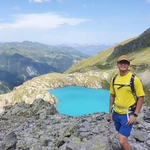
Gallery
Participants
You need to be logged in to see the participants
Weather
°
°
°
°
Description
T4 hike Zindlenspitz (2097 m)
Route: Innerthal - Hohfläschen - Zindlenspitz - Aberliboden - Innerthal circular hike
There are some pictures here, what to expect. The starting and end points are not the same but the rest of the route is identical. Rundwanderung vom Wägitalersee zum Zindlenspitz (tophikes.ch)
Technical difficulty: One part of the hike is T4 alpine hiking path, that is why the hike has a difficulty level of T4. According to the definition is the path not always visible and some sections require the use of hands. There are exposed parts. Good fitness, surefootedness and no fear of heights are required.
This hike is not for beginners.
More details about the grade: https://www.sac-cas.ch/fileadmin/Ausbildung_und_Wissen/Sicher_unterwegs/Sicher_unterwegs_Wandern/2020_Berg_Alpinwanderskala_EN.pdf
Pace: moderate with some breaks. There is around 1200 m gain of elevation.
Weather forecast: sunny
Getting there: with public transport. Meeting point is at the beginning of the platform at Zürich HB shortly before train departure.
07:43 S25 train Zürich HB - 08:16 Siebnen-Wangen
08:34 B 523 bus Siebnen-Wangen - 08:56 Innerthal, Post
Total travelling time: 1h 13min.
Getting back: the same connection, there is a bus every hour.
Starting point and time: Bus stop - Innerthal, Post at 9:00
What to bring:
- Proper hiking shoes with good grip
- Enough snacks, packed lunch and water. Lunch-break will be on the peak. There are no restaurants on the top
- Sunscreen, sunglasses
- Clothes according to the weather
- Hiking poles are recommended for the way down
- Recommended to have the gpx data of the hike on phone (Swisstopo app) or watch
Group size: max. 12 people, as the transportation is partially with bus.
Cancellation: up to 12 hours before the start of the event.
Disclaimer: I am not a professional guide. Everybody is responsible for her/himself. Make yourself familiar with the route and its requirements. Please note that this is not a hike for beginners.
Comments
Minh
2 years ago
WhatsApp chat: https://chat.whatsapp.com/FKsgwd6MrSP5ZxyECh23wC
1
|
0