Uploading...
Overall progress...
0%
File progress...
0%
Edit event: [CH] T4 Ridge Hike Rophaien
T4 - [CH] T4 Ridge Hike Rophaien
 Organized by:
Route
Eggberge - Rophaien
| Elevation gain |
| Elevation loss |
| Distance |
| Duration |
| Highest altitude |
| Rating |
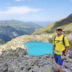
Gallery
Participants
You need to be logged in to see the participants
Weather
°
°
°
°
Description
T4 Ridge hike
Rophaien (2078 m)
This hike
is not for beginners!
Route: Eggberge – Franzen – Rophaien – Äbneter Stöckli – Firtiggrätli – Hüenderegg – Eggberge circular hike
This is a ridge
hike. There are some pictures here, the exact routes of these hikes might differ:
- Eggberge – Rophaien loop from
Altdorf | hike | Komoot
- Hoch über dem Urnersee - Von den Eggbergen zum Rophaien [hikr.org]
Technical difficulty: One part of the hike is T4 alpine hiking path, that is why the hike has a difficulty level of T4. According to the definition is the path not always visible and some sections require the use of hands. There are exposed parts. Good fitness, surefootedness and no fear of heights are required.
This hike is not for beginners! There is around 1100 m gain of elevation and a technical level of T4, so a good fitness level is a requirement.
More details about the grade: Bewährtes und Neues aus dem SAC-Verlag (sac-cas.ch)
Pace: moderate with some breaks.
Weather forecast: sunny
Getting there: with public transport. Meeting point for the people, who come from Zürich, is at the beginning of the platform at Zürich HB shortly before train departure.
- 07:35 IR75 train
Zürich HB - 08:02 Zug
- 08:07 S2 train Zug -
08:48 Flüelen
- 08:51 B401 bus
Flüelen, Hauptplatz – 08:52 Flüelen, Eggberge Talstation
Total travelling time: 1h 17min with public transport.
Getting back: the same connection, every half an hour. Please don’t plan anything after the hike as the hiking time is around 6h (without breaks) and we need time for getting up and down with the cable car.
Meeting point and time: Flüelen, Eggberge Talstation (Cable car valley station) at 9:00
Cable car: We will use the cable car to get to the starting point of the hike. I am counting half an hour for each way (buying tickets, waiting, travelling time). Return ticket costs CHF 22.-
What to bring:
- Proper
hiking shoes with good grip
- Enough
snacks, packed lunch and water. Lunch-break will be on the peak at around 1 pm,
we will have a small snack break before it. There is no restaurant on the top.
- Sunscreen,
sunglasses
- Clothes
according to the weather. Also an additional layer for the lunch break, as it
can get windy on the top
- Hiking
poles are recommended for the way down
- Recommended
to have the gpx data of the hike on phone (Swisstopo app) or watch
Cancellation: up to 12 hours before the start of the event.
Disclaimer:
I am not a professional guide. Everybody is responsible for her/himself. Make
yourself familiar with the route and its requirements. Please note that this is
not a hike for beginners.
Comments
Minh
2 years ago
https://chat.whatsapp.com/HOh6PHqdklR3Lw1m5v0JHq
0
|
0