Uploading...
Overall progress...
0%
File progress...
0%
Edit event: Daniel (2,340 m) & Upsspitze (2,332 m)
T3 - Daniel (2,340 m) & Upsspitze (2,332 m)
 Organized by:
Route
Daniel & Upsspitze from Lermos
| Elevation gain |
| Elevation loss |
| Distance |
| Duration |
| Highest altitude |
| Rating |
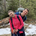
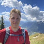
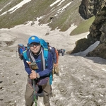
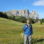
Gallery
Participants
You need to be logged in to see the participants
Weather
°
°
°
°
Description
NOTE: Please be punctual! Train could be fully packed, so better to be on the safer side and take a seat as early as it is possible.
NOTE: Please check the gain and distance of the hike, it may not be beginner friendly.
The Daniel (2,340 m) is a mountain in the Austrian state of Tyrol, and the highest peak in the Ammergau Alps, a range within the Northern Limestone Alps. Located near the villages of Ehrwald and Lermoos. With the almost equally high Upsspitze (2,332 m) it forms a double summit.
The summit may be reached on an easy mountain tour from the south, sure-footedness only being required on the summit arête from the Daniel to the Upsspitze. The ascent on the normal route starting at Leermoos and passing over the Tuftlalm and the Upsspitze takes about 3–4 hours according to the literature. A descent back over the Upsspitze, the ''Grünen Ups (a viewing point), and the Tuftlalm to Lermoos takes about 2½ hours.
The summit offers a splendid view of the Zugspitze massif to the east and the Mieminger Range chain to the south.
Good to know
We will meet at Munchen Hbf (Gl. 31). Please be punctual! Train could be fully packed, so better to be on the safer side and take a seat as early as it is possible.
The hike should take ca. 7 hours (with the stop at the hut going back to Lermoos AND with an intermediate pace of 400 mph).
The plan is following:
7:13 - 8:22 (RE 61) München Hbf -> Garmisch
8:26 - 9:58 (RE 62) Garmisch -> Lermoos
9:00 - 16:00 hiking + stop at Tuftl Alm hut
16:25 - 16:59 (S 7) Lermoos -> Garmisch
17:05 - 18:26 (RB 6) Garmisch -> München Hbf
It may change depending on the weather, hike & availability of the connections.
Sticks may be helpful to keep you safe.
Before the hike please join the WhatsApp group or send me a private message with your phone number.
WhatsApp group: https://chat.whatsapp.com/GkXRe1MO6Ez0bGKCP2eNT3
Things to bring:
- Deutschland Ticket with ID card;
- hiking shoes;
- windproof and waterproof clothes;
- water (at least 3 l) and some food;
- sunscreen and sunglasses;
- good energy and stamina.
Optional:
- hiking poles;
- DAV insurance;
- first aid kit.
Note:
- Unjoining is allowed until 12 hours before the start of the event
- The organizer is no professional guide. Participants are responsible for themselves, must do their own research about the route, and must be able to navigate by themselves (in case the group splits for some reason, for example)
Disclaimer: Hiking can be dangerous. I am not a mountain guide. Everybody is responsible for themselves. Please make yourself familiar with the route and its requirements. Additionally, you could download the map, bring a cell phone and a first aid kit.
Comments
Petra Wieser
2 years ago
Is it ok if I join in Pasing?
I know the train will be packed, but stil.....
Is it ok for you?
0
|
0
Robert Piecyk
2 years ago
Hi Petra, that's fine for me :) See you tomorrow in Garmisch (or Lermoos)!
0
|
0
anup kumar
2 years ago
This is full, can I still join and come?
0
|
0
Robert Piecyk
2 years ago
sure, you can still register (one place is left), but if you cannot register, you can still join us 😀
0
|
0

Tommy JARNAC
2 years ago
Hi Robert, sorry I forgot that I had registered to this and now I see it's less than 12 hours but technically can't unjoin, sorry for this!
0
|
0
Robert Piecyk
2 years ago
Hi, fully understood… That’s a pity that you won’t join us 😕
0
|
0
Abdelrahman Salim Hammoud
2 years ago
Could I please unjoin?
0
|
0