Uploading...
Overall progress...
0%
File progress...
0%
Edit event: Klettersteig Klamml (C/D) plus Gipfel Ellmauer Halt A/B) (2344 m)
T5 - Klettersteig Klamml (C/D) plus Gipfel Ellmauer Halt A/B) (2344 m)
 Organized by:
Route
Klettersteig Klamml plus Gipfel Ellmauer Halt (2344 m)
| Elevation gain |
| Elevation loss |
| Distance |
| Duration |
| Highest altitude |
| Rating |
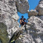
Gallery
Participants
You need to be logged in to see the participants
Weather
°
°
°
°
Description
Not beginner friendly, Alpine Hiking experience (Via ferreta experienceneeded)
This hike is subject to change if the weather is not good
Hikers, lets enjoy reamaining summer time in mountains
I'm excited to say that I'll be going on another hike this Saturday. It would be great to have some awesome hikers join me. However, I kindly request that only those who are genuinely committed and physically capable of keeping up with the group's pace participate.
Flexibility is essential, and a good sense of humor is always appreciated. Please remember to bring necessary equipment you think you'll need.
Via ferreta set & helmet is must have , also bring your pass ID as we cross border
I want to clarify that I am not a mountain guide, so please assume responsibility for your own presence and safety.
Please note from Kufstein we have to buy a ticket for bus in Austria.
Lastly, I will create a WhatsApp group on Friday to facilitate better communication. It would be wonderful if you could join the group for updates and coordination.
This time, I won't be arranging group tickets, as I assume most people already have the 49 Euro ticket. If you require a group ticket, you can team up with others in the WhatsApp group to organize it.
Looking forward to an amazing hike!
Best regards,
Amir
| München hbf(platform 9 (RBB RE 5 Salzburg) 5:55 | Rosenheim 6:37 (platform 4) |
| Rosenheim 6:41 (kufstein) | Kufstein 7:21 |
| Kufstein(bus 4902) 7:40 | söll Kreisverkehr 8:03 |
| Söll Kreisverkehr (bus 4060) 8:11 | ellmau dorf 8:25 |
| Ellmauer dorf (Bus WBWA) 9:00 | Wochenbrunner alm 9:15 |
Good to know
 boarding
Start at the Wochenbrunner Alm and hike along the forest path 812/822 in the direction of Gaudeamushütte. Here you turn onto trail 813/824 in the direction of Gruttenhütte via Klamml and follow it until you reach the start of the via ferrata.
Walking time ascent (recommended value)
1:20 hrs for Klettersteig Klamml and totally 5-6 hrs
descent
There are three descent options:
From the Gruttenhütte via trail 825 to the Wochenbrunner Alm.
On the Gruttenweg 14a and further on the trail 822 past the Ellmau stone circle to the Wochenbrunner Alm.
On the Klammlweg 813/824 - partly running directly under the via ferrata - to the Gaudeamushütte and further on the path 812/822 to the Wochenbrunner Alm.
Walking time descent (reference value)
1:00 a.m
getting there
Public transport
The free hiking bus runs daily in summer between the Ellmau Dorf/Bauhof stop and the Wochenbrunner Alm hiking starting point. There is also the option of changing to/from the KaiserJet and the regular buses at the Ellmau Dorf/Bauhof stop.
More information at www.wilderkaiser.info/mobil
Arrival by car
Coming from Wörgl or Kufstein on the B178 federal road, take the Ellmau exit and then the first exit at the roundabout. Follow the road straight ahead until you reach the junction (green signs) towards Kaisergebirge/Wochenbrunn. Turn left here and immediately right again. Now follow the road (toll road) until you reach the Wochenbrunner Alm car park.
Coming from St. Johann on the B178 federal road, take the Ellmau exit and drive straight ahead to the Bauhof junction (green signs - towards Kaisergebirge/Wochenbrunn), turn right here and immediately right again. Now follow the road (toll road) until you reach the Wochenbrunner Alm car park.
The normal route to the highest peak of the Kaisergebirge begins at the hiking starting point at the Wochenbrunner Alm. Here you first follow path 825 to the Gruttenhütte. After a short break, it goes up into the large gravel cirque "Hochgrubach". On the following ascent over the Gamsängersteig, there is a great danger of falling rocks from previous climbers. In the first section of the climb, you cross steep, rocky terrain that is interspersed with grass and brittle (Schrofengebiet – only partially secured with steel cables) until you reach the Jägerwand stairs with over 70 steps just below the Rote Rinnscharte. Then it goes over several rope-secured passages to a fork in the road. There are two options here, either left through a narrow gorge and over a short vertical ladder or right, very exposed along steel cables onto a rock terrace. From here you climb over more rock steps and past the Babenstuberhütte (emergency bivouac) to the summit. Enjoy the fantastic 360° panorama from the highest point in the Kaiser Mountains.
(Ascent from the Gruttenhütte to the summit in approx. 2h 30 min)
Attention - snow fields can often be expected well into the summer!
Comments
Piyush Panse
2 years ago
Hello Amir the gpx file gives value of 1152 elevation gain.....and below you say ascent time 1:20 I would like to join but not sure I can hike at 800 hm/hr......do you plan to go this fast.....
0
|
0
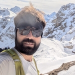
Amir ak
2 years ago
Hi Piyush, sorry 1:20 is just for via ferreta part klammel, we will need 5-6 hours to complete it and we are going to do that in normal pace,
0
|
0
Amir ak
2 years ago
Weather seems excellent for hike tomorrow. Please join the whatsapp group for hike tomorrow
https://chat.whatsapp.com/CuuBIBbXfxtBZLYgOPVAlX
0
|
0
Piyush Panse
2 years ago
Is there platform change
0
|
0
Piyush Panse
2 years ago
I am in train ...I cant find you
0
|
0
Amir ak
2 years ago
Pöease join the whats app group
https://chat.whatsapp.com/CuuBIBbXfxtBZLYgOPVAlX
0
|
0