Uploading...
Overall progress...
0%
File progress...
0%
Edit event: [Switzerland ]Wirzweli - Arvigrat - Wirzweli [T3]
T2 - [Switzerland ]Wirzweli - Arvigrat - Wirzweli [T3]
 Organized by:
Route
Wirzweli - Arvigrat - Wirzweli
| Elevation gain |
| Elevation loss |
| Distance |
| Duration |
| Highest altitude |
| Rating |
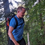
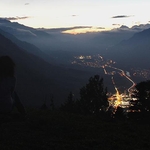
Gallery
Participants
You need to be logged in to see the participants
Weather
°
°
°
°
Description
General information
Route: T3/T4 (not T2), just don't be too scared of heights, have shoes with good grip. If you don't know what the T-Scale is, read this blog (click here).
Pace: Moderate pace, for which you won't have any problem if you're doing sports regularly.
Meeting point: Wirzweli station - 09:40 (Shuttle Bus from Dallenwil station to the starting point)
Transportation:
Public transport:
The starting time (09:40) makes it possible to take a train from Zürich (arrives at 09.30 at Dallenwil, change in Luzern).
Car:
At Wirzweli station parking slots (cost about 6,-) available
In both cases, add / join a car in the Carpool screen. If you come by train, add a "fake car".
To do before the hike
- The day of the hike AND one hour before the hike, come have a look at the comments at the bottom of this page to know about potential last minute updates.
- Prior to the hike, please download the GPX file and have it imported in a GPS application on your phone. See my Facebook post about GPS apps. You can download the file from this event page.
Known bug: Make sure the file you have downloaded has a .gpx extension. If not, just rename it, as it might happen that you get a ".gpx.xml" file instead of just ".gpx" when downloading from a phone.
Schedule (approx.)
- 09h40: We start hiking from the starting point mentioned above.
- 12h00: Peak & lunch break.
- 15h00: Station.
Gear
Hiking shoes, warm clothes for during break on the top, food, water, sunscreen, hat, glasses, whatever else you need for a good day in the mountains.
Additional notes
- Out of respect for the others, please be on time. My events usually start exactly at the indicated time.
- Some of the hikes I organize (not necessary this one - that's just a copy paste) may require experience / minimum pace, in which case I might need to contact you. Please keep an eye on your emails.
A few things about Hiking Buddies platform:
- The organizer is no professional guide. Participants are responsible for themselves, must do their own research about the route, and must be able to navigate by themselves (in case the groups split for some reason, for example).
- Unjoining allowed until 12 hours before the start of the event.
- If you have a No Show in your profile ( = you did not show up to a hike you signed up to in the past), I may exclude you from the event
Transportation
This is a carpool event, possibly combined with people coming by public transports. Anyone else with a car can add it via the Carpool button at the top of this page. If you join by public transports, see the guidelines further down.
Instructions for joining car
- Click on the Carpool button.
- If there's any available seat, click Join car. You have 12h before the event to unjoin, but the earlier the better so that someone else can join.
How can I join by public transports?
Case 1: You are the first one joining by public transports
- Click on Carpool (top of the page)
- Click on Add a car (even if it is not actually a car)
- Set the number of seats available to 0
- In the field Contact details, write "Public transports"
- The other fields aren't relevant.
Case 2: Someone else already added a fake car for public transports
- Click on Carpool (top of the page)
- Click on Join car
Comments
Sergio Dalsass
2 years ago
Hi Rolf,
So you take the train that arrives in Dallenwil at 9.30?
0
|
0
Rolf Friederich
2 years ago
Hi Sergio,
Yes, then normally there's a shuttle bus to Wirzeli cabine station. If not it's about 12min by walk. Cu Rolf
0
|
0

Robert B
2 years ago
Hey Rolf, It would be nice to meet at Dallenwil, the train from Luzern arrives at 9:29, Do you think it is fissile to get to a starting point within 10 minutes?
0
|
0
Rolf Friederich
2 years ago
Hi Robert, see meeting point description - there should be a shuttle bus to Wirzweli station. Cu Rolf
0
|
0
Sergio Dalsass
2 years ago
@ Zurich people: with the current schedule, in order to be at Dallenwil at 9.30, the best train connection from Zurich is IR75 leaving at 7.35. We could meet at 7.20 / 7.25 at the beginning of platform 7
0
|
0
Rolf Friederich
2 years ago
Hi Sergio
Zürich mainstation 08:10 is the better connection with lesser waiting time in Luzern. Cu Rolf
0
|
0
Sergio Dalsass
2 years ago
You are right
0
|
0
Sergio Dalsass
2 years ago
CORRECTION: @ Zurich people: the best train connection is IR70 leaving from Zürich HB at 8.10. We could meet at 7.55 at the beginning of platform 8 (that train will be very crowded)
0
|
0

Vyron Bouloumis
2 years ago
Hi Sergio.I will be there at 7:50. See you tomorrow!
1
|
0
Robert B
2 years ago
my train arrives to Zuri HB at 8:00, I catch up with you guys than there.
0
|
0

Sofie Katan
2 years ago
I’ll join you as well at HB:)
0
|
0
Zita
2 years ago
Hii Sergio, I will jump in the train in Zug. Hope to see you guys at least in Dallenwil as I don’t really see the bus connection 😅 see you tomorrow!
0
|
0
Rolf Friederich
2 years ago
Hi Zita, it's a privat shuttle from Wirzweli destination, not SBB - see their website. Cu
1
|
0
Vyron Bouloumis
2 years ago
Good morning everyone. The platform is number 11. I am waiting here. I wear a gray jacket
0
|
0
Sofie Katan
2 years ago
Which end? I come from sihlpost
0
|
0
Vyron Bouloumis
2 years ago
I am with Sergio at the beginning of the platform
0
|
0
Vyron Bouloumis
2 years ago
We are in the first Wagon. Up
0
|
0
Sergio Dalsass
2 years ago
In the ir70 we are in the first Coach in the traveling direction
0
|
0
Robert B
2 years ago
Do you have a free sit there on a coach, in the first vagon? Im somewhere in the middle
0
|
0