Uploading...
Overall progress...
0%
File progress...
0%
Edit event: [Switzerland] Meglisalp – Seealpsee loop from Wasserauen (optional Ebenalp, +400m of elevation gain)
T4 - [Switzerland] Meglisalp – Seealpsee loop from Wasserauen (optional Ebenalp, +400m of elevation gain)
 Organized by:
Route
Meglisalp – Seealpsee loop from Wasserauen
| Elevation gain |
| Elevation loss |
| Distance |
| Duration |
| Highest altitude |
| Rating |
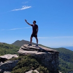
Gallery
Participants
You need to be logged in to see the participants
Weather
°
°
°
°
Description
Greetings,
This trail is perfect for Autmn. We might see many beech trees with reddish leafs.
Those who want to come by public transport should join my virtual car in the carpool.
The route will pass through these highlights:
Waterfall Hüttenobel, Meglisalp, Seealpsee.
Starting and end point: Wasserauen, Bahnhof
How to arive there:

Elevation gain and loss: around 1084 m (without the optional part)
Highest point: 1884m
Pace: Moderate, this is not a hike for beginners
Everyone should have: Hiking shoes, proper clothes (depending on the weather), food, and water. Whoever is sensitive to sun should take sunscreen.
I might cancel or reschedule the event in case the weather deteriorates by Sunday (this will probably not happen)
Optional: When we arrive at Seelpsee, those who are still motivated can continue to Ebenalp (400m+ of elevation gain). The route to Ebenalp is not presented on the map.
Comments

Jean-Sebastien
2 years ago
Hi all, see you tomorrow ! have a good day, JS
1
|
0
Atanas Bayraktarov
2 years ago
Link to the whatsapp chat: https://chat.whatsapp.com/LD3TkD5AQ9fH4IzrmAkscj
0
|
0
Jean-Sebastien
2 years ago
Hi, for unknown reason I cannot join the WhatsApp group. But I am at the station.
0
|
0
Atanas Bayraktarov
2 years ago
where are you exactly ? turn off the power saving and try to join the whatsapp group
0
|
0