Uploading...
Overall progress...
0%
File progress...
0%
Edit event: Hirschberg (Winter)
T2 - Hirschberg (Winter)
 Organized by:
Route
Hirschberg (Winter)
| Elevation gain |
| Elevation loss |
| Distance |
| Duration |
| Highest altitude |
| Rating |
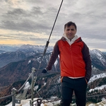
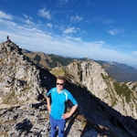
Gallery
Participants
You need to be logged in to see the participants
Weather
°
°
°
°
Description
Meeting Time: 7:55 at München Hbf Gleis(Plattform) 33. Train leaves at 8:03. -->BRB RB57 to Tegernsee
Important: It is neccesary to have Deutschland tickt(49 euro) otherwise you should by yourself.
Route maybe modified based on the conditions of the day of the hike.
Wish to board the train to Munich before it goes dark.
Go through the route and if possible save the gpx and the map of the area in your navigation device for offline use.
Mandatory: Come with a good mood and smile :)
For queries, write in comments
Note: Please unjoin the event well in advance, if you don't plan to come. You cannot unjoin the event when it is starting in less than 12 hours
Important Info:
Because of Weather condition Event can change.
Estimated Plan:
| Munich Hbh (RB57) -->Tegernsee Bhf(BUS 356)->Scharling-Hirschbergweg | 8:03 -->9:09-->9:17-->9:44 |
| Hiking (app. 5 H) | 9:44 -- 16:00 |
Food / Drinking (1 H) | 12:00 - 13:00 |
| charling-Hirschbergweg(BUS356)->Tegernsee Bhf(RE57)----->Munich Hbh | 16:09-->16:37-->16:52->17:57 |
Good to know
Remember to bring with you:
--Food/water
--Hiking poles
-- Rain protection
--Spikes + gaiters
--Gloves
--Headlamp and first aid kit (for emergencies)
--Cash for optionally the beer garden / restaurant
--Please bring your food/drink for yourself in advance.
--DAV Insurrance
Disclaimer: Hiking can be dangerous. I am not a mountain guide. Everybody is responsible for themselves. Please make yourself familiar with the route and its requirements. Additionally, you could download the map, bring a cell phone and a first aid kit.
Comments
2 years ago
Sodayf and girls🙂
2
|
1
Sodayf Ahadi
2 years ago
😃
0
|
0
Sodayf Ahadi
2 years ago
watsup group link: https://chat.whatsapp.com/F8PP1CDSturCYVwAyfgDMO
0
|
0
Martin Strahl
2 years ago
Hi, would it please be possible to increase the number of participants? There are so many people who I saw on other hikes. And it would be nice to see them again.
0
|
0
Martin Strahl
2 years ago
Thank you very much. Now I think it's possible to get into the hike.
0
|
0
Sodayf Ahadi
2 years ago
we are in Train wagen Tegernsee
0
|
0